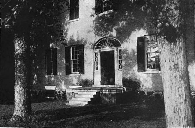
In keeping with the holiday, my first stop was to visit a recreation of the home of Benjamin Banneker, a self-taught African American who studied astronomy and mathematics; wrote a series of almanacs with information on sunrise and sunset timing, solar and lunar eclipses, and other information; corresponded with Thomas Jefferson on issues such as slavery; and helped survey the area that later became the District of Columbia, using celestial surveying techniques. He lived from 1731 to 1806, leaving a legacy of outstanding accomplishment.


Banneker lived in Ellicott Mills (now Ellicott City, MD) in an area very close to what later became known as Oella, a mill town. Oella features a couple of scenic churches, including the Oella Methodist Episcopal Church (now an office building)…

…and the historic Mount Gilboa Chapel, constructed by a congregation of free African Americans in 1859 and with an obelisk in honor of Banneker.

Oella was named after the first woman to spin cotton in the U.S. It thrived as a mill town for 150 years, but the mill closed in 1972—and later that same year, Hurricane Agnes devastated parts of Oella and most of Ellicott City. Afterward, Oella deteriorated rapidly. Fortunately, with the help of the Oella Company and a community organization, Oella has since become a trendy residential, shopping, and tourist area. Among other attributes, it features one of the tightest, winding, switchback roads in all of Maryland (Oella Avenue).

I believe this building was once a hotel for travelers. It has been converted to a series of residential apartments.

On the outskirts of Ellicott City, St. John's Episcopal Church still stands proudly, having served the area continuously since 1859. It features a spire that is made of solid granite and is 83 feet tall. It was a windy day, and I decided not to park the Z4 too close…

Burleigh Manor was once the home of Colonel Rezin Hammon, who served in the Revolutionary War and helped burn the British ship Peggy Stewart, complete with its load of tea, in Annapolis in 1774. Following the instructions in the New Guide, I set off to find and photograph the manor. After a lot of hunting around and even (horrors) stopping to ask someone, I found the following dwelling, hiding behind a row of trees. Satisfied, I moved on. But subsequent research proved that this is some other mansion, and not Burleigh Manor. Hmmph!

The National Register of Historic Places came to the rescue with the following photo of Burleigh Manor. And now I have the proper address and can track it down the next time I'm out. The second photo, of the mansion's garden entrance, is from a 1914 book of colonial mansions in Maryland. The book's description includes the following statement: "A feature of the grounds of Burleigh which lends much to its romantic atmosphere is the old slaves' quarters a short distance from the house." On the anniversary of Martin Luther King's birth, it's a useful reminder of how much has changed for the better.

I next set my sights on the famous Doughoregan Manor, the home of Charles Carroll III, one of the signers of the Declaration of Independence. It was built by Charles Carroll II in 1727 and has remained in the Carroll family ever since. I'd wanted to see it for years. With help from Google Maps, I knew exactly where to find it, and I'd even picked out some good vantage spots from Manor Lane, where I could get photographs without having to intrude onto the property itself. The best laid plans… It turned out that Manor Lane is now marked as a private road, with numerous threats of criminal prosecution for trespassing. (Boo! Hissssss!) In desperation, I circled around to the adjoining Paul's Lane—which also proved to be private. In the end, I got no closer than a half mile to the mansion and couldn't even see a corner of it. But if I'd actually been there, my picture of the 300-foot-long Doughoregan Manor would have looked like this (courtesy of the Maryland Historic Trust):

Next up in my search for manors was Walnut Grove, the home of Revolutionary War Colonel Gassoway Watkins and built sometime between 1740 and 1780. Fortunately, it was easy to spot off in the distance from Folly Quarter Road.


Other mansions were practically next door. The present-day Companions of St. Anthony friary was built upon the Folly Quarter estate in 1930. The granite mansion was a gift of Charles Carroll III (remember him?) to his favorite granddaughter, Emily Caton in about 1830. The estate is believed to have been an important part of the Underground Railroad prior to and during the Civil War, helping escaped slaves reach freedom in the North. The mansion now serves as an office building for the friary, but it's open to the public on special occasions.


While you're off exploring, it's always best to park your BMW so that it has a nice view.

Just a couple of miles further down the road sits the Glenelg Manor, now part of the Glenelg Country School. The school was closed for the holiday, fortunately, as that meant there wasn't anyone around to chase me off the grounds. The manor itself was quite impressive, being made of Ellicott City granite and British marble. The older part was built by Ephraim Howard in the mid-1700s, with the newer part added in the mid-1800s by General Joseph Tyson, who named the estate Glenelg in part because it spelled the same word frontwards or backwards.

The Waverly estate lies just off of Marriotsville Road. The land was patented by Yet Another Carroll (Daniel in this case), who named it "The Mistake." The manor was initially constructed in 1760 and was owned by various Dorseys and Howards until the son of Maryland Govenor John E. Howard received it as a wedding present. He and his new bride named it Waverly, after a novel by Sir Walter Scott.

Yet another reminder of past practices was evident at Waverly. This building served as a jail for slaves.

Following a multitude of back roads, many of them quite familiar from my motorcycle trips, I headed toward Sugarloaf Mountain in Frederick County. This prominent outcropping stands about 800 feet higher than the surrounding countryside and was formed as all of the surrounding area was eroded away over a period of 14 million years, leaving its tough quartzite rock standing alone. From the mountain top you could see for many miles. From here, Union forces spotted General Robert E. Lee's army crossing the Potomac at White's Ferry in 1862 to begin the first Confederate campaign in the North. As part of this invasion, the Confederates captured Sugarloaf Mountain and marched on to Antietam.

Can you spot this farm in the picture above? (Yes, it's there. Nothing like a 20x zoom lens!)

A wealthy Chicago businessman, Gordon Strong, bought the mountain in the early 1900s (some say by posing as a poor woodcutter to get a better price). Strong engaged Frank Lloyd Wright to design a spectacular "automotive objective" and planetarium at the top of the mountain, but it was never built (see drawing below, courtesy of About.com).

Instead, Strong built several observation areas, including this one…

…and the "Stronghold" mansion. The Strong family has turned the mountain into a free park, with miles of hiking trails. Although I'd previously ridden my R1200GS up the mountain, on this visit I noticed a prominent "No Motorcycles" sign. (I don't remember doing anything bad when I was there on the bike…was it something I said?)

This is the Westwood Mansion, which sits close by on Sugarloaf Mountain and is now an elegant inn and restaurant.

Although it was a beautiful day for a trip, with temperatures in the low 40's, a lot of ice remained on the beautiful pond at the base of the mountain—much to the delight of any nearby photographers.

Not far from Sugarloaf Mountain, the Monocacy River joins the Potomac. The Chesapeake & Ohio (C & O) Canal runs parallel to the Potomac all the way from Washington, DC to Cumberland, MD. Getting the canal over such major rivers as the Monocacy presented many challenges. The usual solution was to build an aqueduct to carry the canal boats safely across. The Monocacy Aqueduct is the largest of them and is an impressive sight. I couldn't resist a little HDR magic to capture this admittedly over-the-top psychedelic picture.
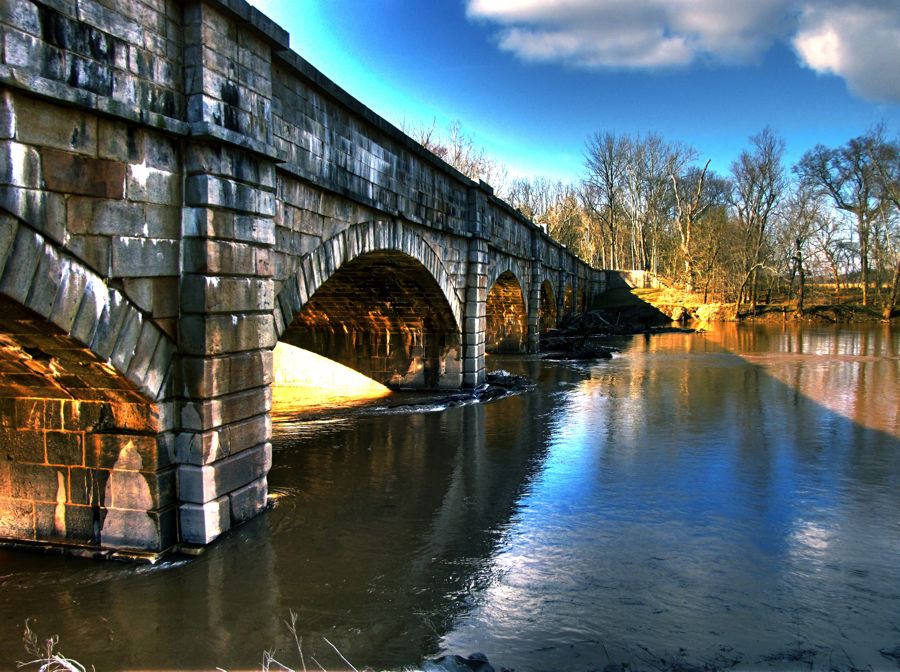
This (regular) view provides a better idea of how the aqueduct carried the canal across the river.

Below the bridge, I discovered this happy family fishing on the banks of the Monocacy.

My trip was beginning to wind down, but I still had a couple of stops to go. The first was in Poolesville, MD, which, somehow, I'd never been through. This charming former bank seemed to sit in the very middle of the town's main street.

In the 1790s, John Poole, Jr. built this log cabin and ran it as a store as the town began to grow around him. It's not a recreation; this robust cabin has withstood storms, floods, fires, termites, and you name it for the last 200+ years.

My final stop was at the fabled Glen Echo, a few miles outside of Washington, DC. I was searching for the home of Clara Barton, the famous war-time nurse, humanitarian, and founder of the American Red Cross. In addition to her efforts to organize hospitals and treatment for wounded soldiers during the Civil War, she worked with Frederick Douglass as an abolitionist. While tending a wounded soldier during the battle of Antietam, she felt a tug on the sleeve of her dress; looking down, she discovered that a bullet has passed through her sleeve and, sadly, through her patient, killing him on the spot. (Photograph courtesy of the National Park Service.)

Clara Barton spent the last 15 years of her life living in this house (which served as the Red Cross headquarters and was, apparently, designed by a committee).

Of course, Glen Echo is best known as the site of a "chautauqua" retreat in the late 1800s and, subsequently, an amusement park. The park became enormously popular prior to World War II but was controversial because its owners refused to allow African Americans to enter. Eventually, following protests and sit-in's, the park was desegregated in 1961. Glen Echo was abandoned in the late 1960s but is now a national park. Much of it has been refurbished, and it once again hosts numerous visitors to its craft classes, dances, and other events. On the day I visited, however, it was largely deserted.


On Martin Luther King Day, almost all of the buildings were closed, including the renovated Dentzel Carousel. Thankfully, I could peak (and photograph) through the windows—and what a sight it was.

From Glen Echo, I loafed back home on the freeways. At 160 miles, this trip was not one of the longer ones. But it was a great opportunity for a top-down drive in mid-January, and I enjoyed every bit of it. Now if I can just figure out how to get a look at Doughoregan Manor…
Rick F.


