Leaving at 7:30, I quickly arrived in Hancock, MD for gas and a snack. After my last trip, I realized that regular stops to (i) stretch, (ii) eat and drink, (iii) etc. were essential for all-day comfort and well-being. This time I promised to follow this advice, even though it meant a little less time for riding and sightseeing.
After various stints on 70, 68, 144, and Scenic 40, I arrived at the real start of my trip: Fifteen-Mile Creek Road, which subsequently turned into Green Ridge Road, leading south through (naturally) the Green Ridge State Forest. Although marked as a significant thoroughfare by my old friends Garmin and Google, it immediately proved to be a completely isolated (and fairly rough) dirt road.

No problem on the ever-willing GS, fortunately, and it led past many an interesting spot. For example, what do you suppose this little building is? A really odd spring house? An unusually sturdy outhouse? The entrance to a Revolutionary War era bomb shelter?

Along the way, there were some magnificent overlooks...

...and those with any fear of heights might want to think twice. One small step would send you roughly 500 feet into Town Creek!

In many places, the road ran right along the very top of Green Ridge Mountain--and the rocks forming the ridge were a fundamental part of the road surface. A little more erosion of the surrounding soil and stones will make this path better suited to mountaineering.

Eventually, I turned west onto the aptly named Pack Horse Road and began a steep descent down off the mountain. At the bottom, I reached the level of Town Creek, one of quite a number of streams that lead from the mountains into the Potomac. Its nice green color added a welcome touch of color to an otherwise-drab winterish landscape.

Oldtown is perched next to the C & O Canal and is named after the really old "Shawnee Old Town" village that had been abandoned by the early 1700s. The paleface version got its start when Thomas Cresap built a stockade fort there in about 1741 and started a business trading with the Indians and frontiersmen. It was a well-traveled spot, since there was a decent ford across the Potomac River.
Regular readers of my ride reports (with good memories) will remember Thomas Cresap. He built "Cresap's Fort" along the banks of the Susquehanna River and promptly tried to convert a lot of Pennsylvania land into Maryland land. After annoying his neighbors on this subject at great length, they eventually formed a posse and arrested him. He later moved to Oldtown and, among other things, worked with an Indian named Nemacolin to convert an Indian path into George Washington's National Road (the original route 40). His stockade fort at Oldtown also served as a one of Washington's series of forts during the French and Indian War. Additional information on this unusual (some might say "reckless") individual is available at http://ftp.rootsweb.ancestry.com/pub/usgenweb/pa/york/bios/gibson/cresap-thomas.txt.
There weren't as many old houses in Oldtown as one might expect from its name, but there were a couple:
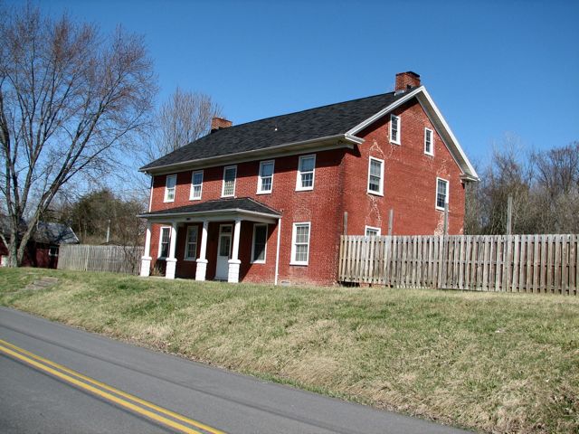
The stone part of this one was built by Thomas Cresap's son Michael in 1746, with the "modern" brick part added in 1781 by the Rev. John Jacobs. George Washington was a regular visitor here over the years. Where was Michael Cresap in 1781? Sadly, after raising an army of 140 men to travel to Massachusetts in support of Gen. Washington's resistance to the British, he contracted a virus and died soon after. He never made it back to Oldtown. More information on Michael Cresap and his house (which is now a museum) is available at http://www.michaelcresapmuseum.org/.

Continuing south from Oldtown on Green Spring Road, I encountered the C & O Canal and Lock 70. The Canal has been refilled here, forming an apparently desirable fishing spot.

Remember the ford across the Potomac that the Indians used? It's now an infamous low-water bridge--one lane, and no guard rails. It's also a toll bridge, costing all of a quarter to cross over. Leaving Oldtown, however, I'd seen an ominous sign indicating that the bridge would be closed on "Easter Sunday, March 25th." Despite the inconsistent day-vs-date, the bridge was, in fact closed. Rather than make a long detour to the next nearest bridge in Paw Paw, WV, I decided to see if there was a way across. It was clear that a lot of debris had swept across the bridge during a recent flood. It was also clear that there weren't no one around...

...so, across I went (and din't pay no 25 cent, neither!) Very soon, I reached the little town of Green Spring, WV. Reaching the town required going through a confusing, 3-way railroad junction and over several track crossings. At least there were interesting things to look at along the way:

My next stop was Fort Ashby, WV, where the bunkhouse of the original fort still stands. While the stockade walls of the fort are long gone, the bunkhouse was used for many years as a private residence, and its original beams are in surprisingly good shape. Fort Ashby saw considerable action during the French and Indian War (as part of then-Colonel George Washington's string of forts) and was also used in the Revolutionary War. Like the Michael Cresap house, this museum can be toured only by appointment--and Easter Sunday wasn't the best day to arrange one. Next time. Note the axe marks still plainly visible in the logs.


My next goal was to locate the original town of Forks of Cacapon. Along the way, Route 28 meandered through Springfield, Raven Rocks, and other current and former towns before paralleling the South Branch of the Potomac River for a ways. Always thinking of President Tina and her love of water pictures, it was time for another photo...

...and another, this one looking at the site of the former Milleson's Mill.

Have you ever been riding along, thinking that you're exploring new territory, and suddenly realize that you've actually been there before? Continuing along Springfield-Millesons Mill Road, I encountered this stately log home--and realized that I'd seen it before, but approaching from the opposite direction. As they say, déja vu all over again...

After a long series of tight, uphill bends, I reached Route 29 and decided--it being 1:30--that it was time for lunch. Fortunately, the Slanesville Pizza and Sub Shop appeared in my sights, and I enjoyed a burger and onion rings, cooked and served up by these friendly ladies:

Turning east onto Route 29, I headed off in search of Forks of Cacapon. In 1750, a young George Washington surveyed the land in this area for Lord Fairfax (of "Fairfax Stone" fame, as JVB and I have written about previously). He returned frequently and later established Fort Enoch here for defense against Indian attacks. I'd been through this area once before in search of Caudy's Castle, which is a mile or so upstream on the Cacapon River--a stunning rock formation that towers 500 feet above the river and one that I'd visited as a kid, canoeing the river with my dad. I borrowed this aerial photograph from the Hampshire County History web site, which has a ton of information about West Virginia's oldeset county and is available at http://www.historichampshire.org/hamphist.htm.

On this trip, however, I was looking for whatever was left of the original town of Forks of Cacapon. With the help of some Internet research before the trip (see http://thecrossingspoa.com/history.htm in particular), I found the "downtown" section of what used to be called Forks of Capon. There wasn't a lot left, but it was fun to explore around a bit. I believe this building was the original Forks of Cacapon post office (which closed in 1910 and was later used as a general store). All that's left of another house that stood nearby on Loy Road is the chimney. There was a smattering of other houses in the area, some old, some new--but overall there was little left of what had once been a thriving area on the "New Road" to Cumberland. It began its decline in the late 1700s, which says a lot.


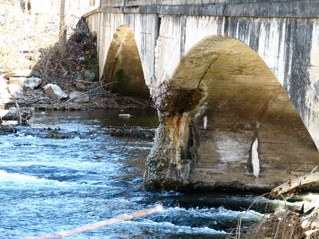
Not far away, on Owl Hollow Road, a one-lane bridge crossed an unnamed stream. Note the deterioration on the downstream middle pier. This bridge's days may be numbered (so ride over it while you can!)

I motored around a bit more, searching vainly for the spot where the North River flows into the Cacapon--which gave rise to the "Forks" name. I never did find it, and it apparently can only be reached by foot. Eventually, I rode the length of Loy Road and then Cabin Run Road to get back to 29. Believe me, there wasn't a lot happening in this remote part of West Virginia!


My itinerary next took me along route 127 through Bloomery and Good and to Sleepy Creek Road--all in the general direction of Gerrardstown and Charles Town, my next two destinations. Sleepy Creek Road was followed by Cumberland Trail Road and Timber Ridge Road--all of them dirt and climbing steeply to the top of the ridge, where more dilapidated buildings and great views awaited.


Crossing highway 522, I reached Chapel Hill Road, which naturally had a chapel:

After a while, the road became Brush Creek Road, and I went by another "Pack Horse Road." While it was tempting to see what that one was like, it was drawing late in the day, and I still had a long way to go. After following Glengary Road through Glengary (don't blink...), I picked up the Washington Heritage Trail at route 51 and proceeded to the wonderful old village of Gerrardstown, with houses dating back as far as 1743. I particularly liked these two...

...but then, this somewhat more recent Ford sedan was also of interest. (What do you think, John--a 1951?) While George Washington had certainly been through Gerrardstown more than once, he may not have slept in this particular historic vehicle.

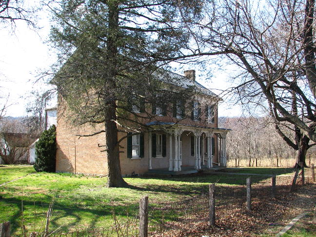
Speaking of George, he of course lived much of his life at Mount Vernon on the Potomac River in Virginia. But a great many of his relatives lived in Charles Town, WV and the area west of there, and George himself owned over 1,500 acres there. After several false starts, I was able to identify "Harewood," the home built by Samuel Washington (youngest full brother of George) in 1770. Among its other interesting facts, James and Dolly Madison were married here, and it's the only Washington home that is still used as a residence by a direct descendant of the Washington family.

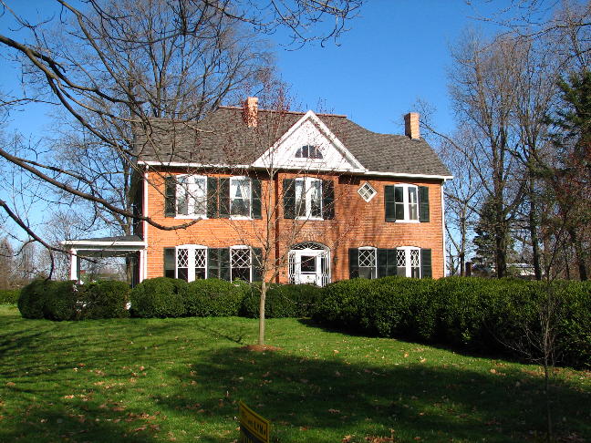
Continuing to follow the Heritage Trail, I passed by numerous other Washington homes, including "Cedar Lawn," "Richwood Hall" (pictured below), "Claymont Court," and "Blakeley."

In Charles Town--oh, did I mention that it's named after Charles Washington, George's youngest half-brother?--I did an R1200GS version of the walking tour (see http://www.charlestownwv.us/Walking%20Tour.pdf?section_id=82). First stop was "Happy Retreat," the home of Charles and his wife Mildred:

Other interesting sites along the tour included the home of Col. Roger Chew, who served under J.E.B. Stuart in the Civil War...

...the Gibson-Todd house, a massive brick home that sits on the land where John Brown was hanged following his siege of Harpers Ferry, with the detail of soldiers led by a Major Thomas Jackson, later known as "Stonewall"...

...the stately Jefferson County Courthouse...

...and this nice-looking but otherwise-unexceptional brick home--which used to stand on Massachusetts Avenue in Washington, D.C., but was disassembled in 1890, moved to Charles Town, and reassembled, apparently brick by brick!
My final stop was at the Zion Episcopal Church. George Washington is not "sleeping" here, but a great many of his relatives are.

After that, it was a quick freeway run back to Catonsville. Overall, the trip was 305 miles and about 10 1/2 hours, counting snack breaks and the occasional stop to take pictures (ahem). The temperature ranged from 28 degrees when I left to a high of about 46. There were a couple of spots of unexpected gravel on paved roads, and more than a couple of roads that were unexpectedly not paved, but nothing of concern. I continue to be amazed by the amount of history that's within an easy day's ride of Washington or Baltimore. To quote Calvin & Hobbes, "There's treasure everywhere!"
Rick F.