"Ghost Towns of the Upper Potomac"

Tell Us About Your Rides!

"Ghost Towns of the Upper Potomac"

Postby Rick F. » Tue Aug 07, 2007 10:15 pm

On the way home from my ride with Neil Peart, a few weeks ago, I stopped for lunch at the Penn Alps restaurant. Their gift shop had an interesting-looking book titled Ghost Towns of the Upper Potomac. I bought a copy, and almost immediately started planning a ride to visit the remaining towns mentioned in the book--and to search for any evidence of the towns that no longer remain.

The North Branch of the Potomac River separates Garrett County, MD from West Virginia. In the late 1800s and through the early 1950s, it was dotted by numerous small lumbering and coal-mining towns. My goal was to trace the Upper Potomac, and these towns, as far as I could.

It's always good to get an early start...
Image


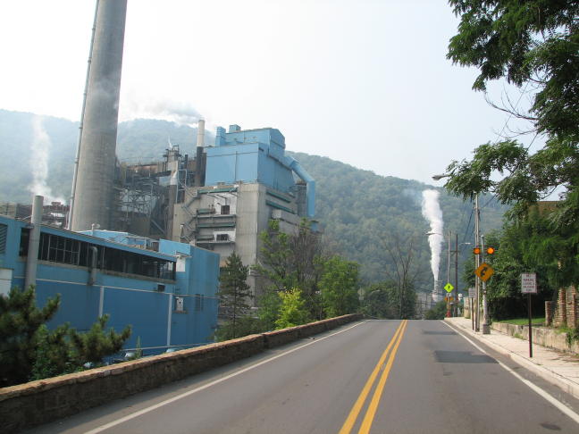
I slabbed it out to Cumberland and spent a little time looking around this town. The stately homes along Washington Street were particularly noteworthy; this was just one of many:
Image


From Cumberland, my route took me south on 220, following the Potomac more or less closely. I took a side detour on Black Oak Road, to get a good look at the river. It's probably just as well that I didn't notice the "Private Property - No Trespassing" sign on the bridge... Who would have such an elaborate, private bridge anyway?
Image


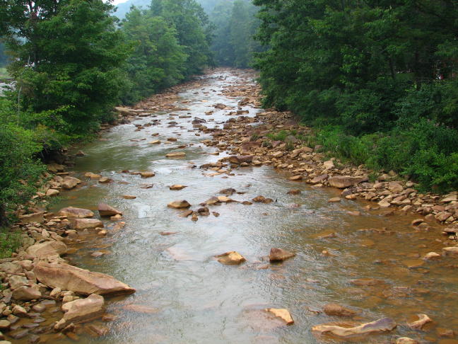
The North Branch of the Potomac was fairly wide and impressive at this point on my upstream travel.
Image


Before long I came to Luke, MD. You don't realize how quaint and scenic these small towns can be until you ride through them...
Image


Moving on to the nearby town of Bloomington, I went looking for the stone railroad bridge built by B&O in about 1850 and still in use today. It proved quite elusive--from several vantage points I could see only a distant portion of it. I finally decided that this path must offer a way to the bridge. Discretion being the better part of valor, I opted to tackle this muddy grade on foot.
Image


After reaching the bottom of the steep and slippery path, I found the river. After wading into the mild rapids a couple of yards, I was able to get the following shot of two-thirds of the bridge. Geez--the things I do to get pictures for you all!
Image


Back on the road, now on the WV side of the river, I began climbing the mountain bordering the river. I stopped here to admire the view and to see what had become of the guard rails. Those aren't bushes in the background--they're the tops of trees.
Image


A sinuous trek through the mountains, on decently paved roads, brought me to Barnum, WV, which was once a prosperous coal-mining town. Except, now, this was the only evidence I could find that there ever was a town here:
Image


Here is the similarly long-lost town of Shaw, WV. To quote from Ghost Towns, in the late 1990s, Bloomington Dam and the resulting Jennings Randolph Lake "made Shaw a memory."
Image


I recrossed the Potomac into Maryland at the twin towns of Blaine, WV and Kitzmiller, MD. There were still a number of houses here, but generally they were newer replacements, and only a few of the older original buildings survived the disastrous flood of March 1924. A rocky and somewhat narrower Potomac was in evidence, but there was little sign of the quaint town pictured in the book. Note the rustic building on the far bank of the river, however: I believe it is the same one pictured on the left in the old photograph (Coffman's Department Store).
Image
Image
Image


By now I was low on gas, so I detoured up to Oakland, MD in search of (i) gas, (ii) lunch, and (iii) a place to stay for the night. I did just fine on the first two, including lunch at the Oak-Mar Restaurant (see p. 106 of Neil Peart's book RoadShow), but I struck out entirely on (iii). It seems that, this close to Deep Creek Lake, every motel in Garrett County is booked up on weekends for weeks in advance.

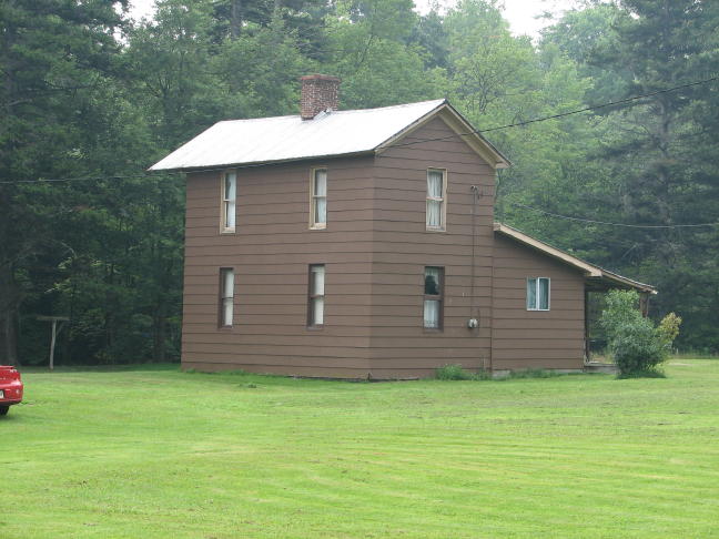
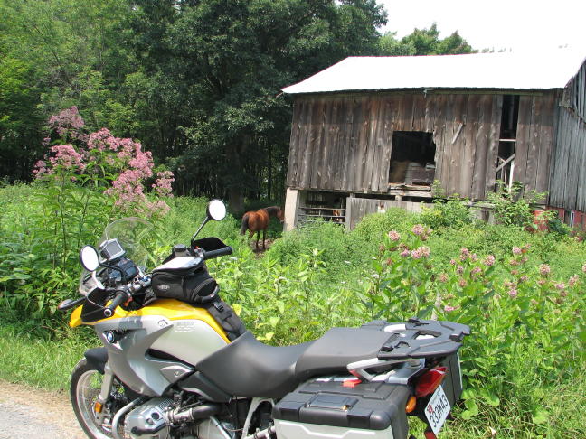
After hustling back to my planned route, I soon ran into the first of my Unplanned Dead Ends. Garmin and Google, those evil twins, insist on showing certain back roads as continuing right along, even when in real life they stop all of a sudden!! At least it wasn't the middle of nowhere, since there were a couple of horses for company. The middle of nowhere was to come later...
Image


Being forced to back-track, however, gave me the opportunity to get this picture, which I'd gone by on the first pass.
Image


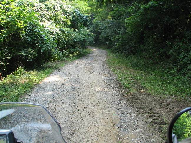
Now, however, it was on to the almost-musical Audley Riley Road, in search of the ghost towns of Schell and Wallman. As it turned out, the road to Schell was paved with good intentions ... and the worst sort of scabrous loose shale, complete with ruts, bumps, potholes, and the occasional kitchen sink to ride over. I jostled along this goat path (formally called Laurel Run Road) for roughly 3 miles, only to find the road closed off a half-mile short of Schell, where it turned into a path that even goats wouldn't take.
Image


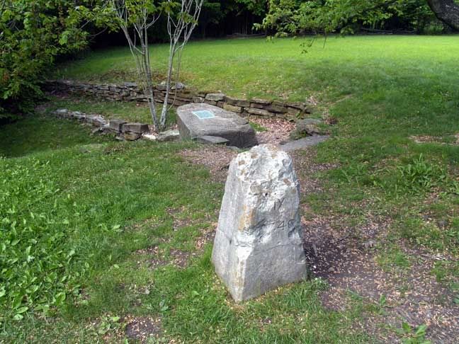
There was an attractive spring nearby. But just out of sight of the photo was a stern warning about the water not being fit to drink by man nor beast.
Image


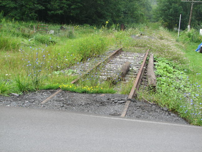
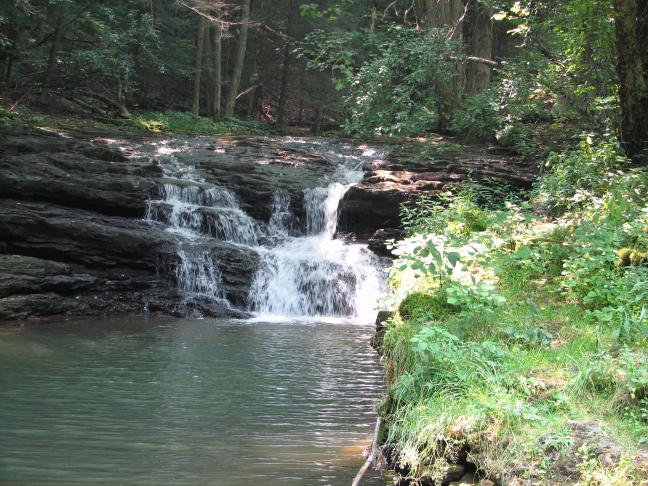
At least Laurel Run proved to be quite scenic and to show some signs of the former habitation.
Image
Image
Image


I retraced my steps and pressed on to Wallman. Wallman, however, was down by the river, whereas Wallman Road was a good 500 feet up the side of the mountain! And it was made of more crushed rock, ditches, etc., complete with relatively steep uphill and downhill sections. A pretty decent challenge, actually--and well and truly in the middle of nowhere. I hadn't seen another car, bike, person, or even a friendly squirrel in quite some time!
Image


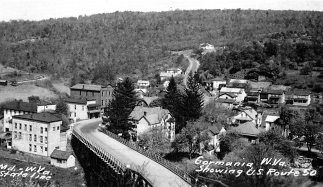
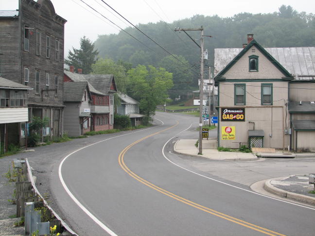
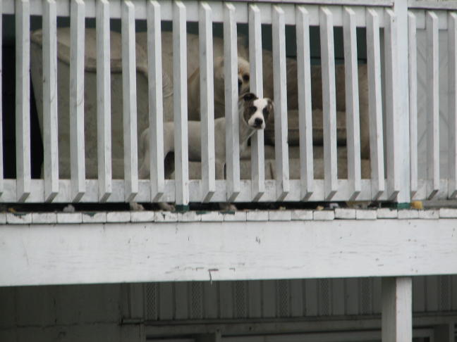
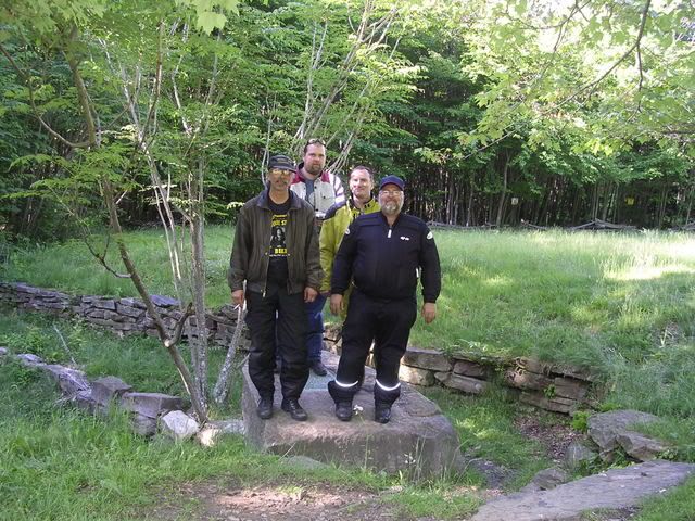
Eventually I went by where Wallman must have once been, 500 feet below, and continued on toward the twin towns of Gormania, WV and Gorman, MD. After roughly 5 miles of the roughest terrain I'd ever been on--it seemed far longer--and only 2 miles short of Gorman, the @#$%&*! road again ended! In fairness, it actually continued, and I might have made it on foot, but there was no way I could wrestle a 500-lb GS up what was left of the trail. These gals and guys, however, were willing to give it a try:
Image


In my case, I turned around and tottered the 5 miles back to civilization and detoured my way to Gorman and Gormania. During the steepest, most difficult section of my climb back up the trail, a large spider fell from a tree and landed right on my nose. As I was desperately trying to keep the GS moving upward, the spider was desperately trying to crawl up and away from this sweating, cursing face! As Neil likes to say, "Adventures suck when you're having them."

Eventually, against all odds, I arrived in Gorman, went west a little ways on route 50, and found a room at the Maryland Motel. I always like to take a picture out of the window of any place I stay. In this case, you can see the window screen (no air conditioning), the front of my GS parked outside, a Scenic Cadillac with 4 flat tires, and the friendly biker bar across the highway. As they say, any port in a storm!
Image


I put my helmet down on the table and took a much-needed shower. When I next lifted the helmet, I discovered that it had left a major sweat ring on the table--that's how drenched it had been from my exertion on an exceedingly hot day. But it had been a very successful ride so far, with more to follow the next day. I slept soundly with many dreams of bounding over an endless series of rocky gullies and ducking under low-hanging branches...

Stay tuned for Day Two of Ghost Towns.

Rick F.
Last edited by Rick F. on Sun Sep 13, 2015 2:43 pm, edited 4 times in total.
For all my tour articles, check out rsftripreporter.net.

2020 Mercedes-Benz SL550
2013 BMW 335i convertible (sold)
2007 Aston Martin V8 Vantage (sold)
2006 BMW Z4 3.0i roadster (sold)
2005 BMW R1200GS (retired)
2003 BMW F650CS (sold)
User avatar
Rick F.
Board Wizard
 
Posts: 1734
Joined: Sun Jul 31, 2005 5:43 pm
Location: Catonsville, MD

Postby Dough Boy » Tue Aug 07, 2007 10:41 pm

Nice Rick, you're getting it dirty!

I went through Luke, MD a few weeks ago. Yuck. :x
Dough Boy
 

Postby BMWGirl » Wed Aug 08, 2007 5:48 am

Great report Rick and YES - we do appreciate the "things you do to get "that one shot" for us"!!! Plus I like the bike pictures!!

Thanks for sharing the rides!
BECAUSE I CAN!!!
IBA #37898 - IBR - 2017 IBA #565 Woohoo

2015 R1200GSA white w/PURPLE :-)
'10 K1300GT
'05 R1200ST

"Riding is about having an adventure - you just go with it and No Whining!" Kermit
User avatar
BMWGirl
GO COWBOYS!
 
Posts: 10126
Joined: Mon Nov 28, 2005 5:00 pm
Location: Queen of the World

Postby JimVonBaden » Wed Aug 08, 2007 7:41 am

Image

Another winner, and looking forward to part two!

Jim 8)
User avatar
JimVonBaden
Smooth Motorcycle Operator
 
Posts: 17669
Joined: Tue Oct 28, 2003 11:48 pm
Location: Alexandria, VA

Postby R4R&R » Wed Aug 08, 2007 9:39 am

Another great report - thanks Rick! I will always look forward to your reports.

I found this picture interesting:
Image

Funny how the barn is not reflected in the water. I know it's the angle of the reflection, but neat.
'17 Triumph Explorer 1200
'04 R1150R (gone but not forgotten)
('13 Triumph Speed Triple - sons bike)
Itchin' for a ride
User avatar
R4R&R
GO COWBOYS!
 
Posts: 1711
Joined: Mon Mar 06, 2006 10:20 pm
Location: Springfield

Postby Ted » Wed Aug 08, 2007 9:47 am

Another great report - thanks Rick! I will always look forward to your reports.


R4R&R beat me to it :)

Bravo!
Image TedV
Moto Pages
'94 K75RT
"There's No Old Road ... That Doesn't Have Something Interesting On It" -- RickF
BMWBMW MoTY - 1996
User avatar
Ted
Board Guru
 
Posts: 682
Joined: Wed Apr 30, 2003 1:26 pm

Postby Flash! » Wed Aug 08, 2007 10:07 am

Image

GREAT pictures, Rick! I loved the Joe Pye weeds in this one.

Jody
You do not need a parachute to skydive. You only need a parachute to
skydive twice.


2012 F650GS, Yellow and Black
User avatar
Flash!
Board Guru
 
Posts: 789
Joined: Sat Jan 22, 2005 7:11 pm
Location: Reston VA

Postby DUKR » Wed Aug 08, 2007 4:14 pm

+1 - Thank you Rick! :D
DUKR
 

Postby Rick F. » Thu Aug 09, 2007 7:23 pm

Dough Boy,

I got the GS plenty dirty, all right--first with the rock dust from Lauren Run Road and Wallman Road, and then from all the rain I rode through on the way home the next day (see the next installment, forthcoming). Luke was a graphic reminder of all the industry that used to border the Potomac in this area. In this case, the Westveco Paper Company was still there in a major way. Across the river in Beryl was the Kingsford Charcoal Company, with a similarly sized (and evil-looking) plant.


Tina,

Getting the picture of the stone RR bridge developed into a major challenge that I just couldn't let go of. I tried 4 different vantage spots (including one that was well onto some company's private, no-trespassing property) before I found the muddy path that finally provided some success. Thoughts of you and your love of river pictures inspired me to continue!


Jim,

Oops, ignore the above note... I'm glad you enjoyed the report on Day One. Day Two will show up later this evening, with any luck.


R4R&R,

I really liked the "reflection" picture, too. The barn was set well back from the pond, so it didn't reflect at all. But it was the kind of place where I'd like to have just sat around in a lawn chair all afternoon, admiring the view and the absence of crowds.


Ted,

Thanks, as always, for your comments. We need to get together for a ride some time--we've each covered a lot of territory in VA and WV but could probably fill in some gaps in each other's database.


Jody,

I was concentrating so hard on getting the horse to look around for the camera (with not much luck, I might add!) that I barely noticed the flowering weeds. Thanks for identifying what kind they are--I wouldn't have had a clue otherwise.


Michelle,

Thank you, too!


Rick F.
For all my tour articles, check out rsftripreporter.net.

2020 Mercedes-Benz SL550
2013 BMW 335i convertible (sold)
2007 Aston Martin V8 Vantage (sold)
2006 BMW Z4 3.0i roadster (sold)
2005 BMW R1200GS (retired)
2003 BMW F650CS (sold)
User avatar
Rick F.
Board Wizard
 
Posts: 1734
Joined: Sun Jul 31, 2005 5:43 pm
Location: Catonsville, MD

Postby Hello Kitty » Thu Aug 09, 2007 7:35 pm

Good stuff, man!! Yeah, Luke. That place is pretty, but it smells AWFUL!!! It's not Westvaco anymore... Can't remember the name. That place is (or was when I worked in Baltimore, assume they still are) a customer of Otis. Lots and lots of calls there.

Anyway, if you head toward Luke from Oakland, the signs warning truckers about the steep grade are amusing. Brooke was particularly concerned about the one that said something to the effect, "TRUCKERS!!! If your brakes fail, ditch truck immediately!"

When we camped out there a few weeks ago, I took some back roads that were just lovely. I wish I could remember the names of some of them... There was a dirt road that went over a mountain, maybe 5 miles long. About half way back, there's a pit toilet out in the middle of nowhere. Very weird!
Kitty
User avatar
Hello Kitty
Boss of Tina
 
Posts: 7474
Joined: Tue Sep 21, 2004 8:13 pm

Postby Maria V » Thu Aug 09, 2007 8:04 pm

I love these posts, Rick. Another fine job. :D
Maria
Retired Presidente
Kermit's Ride Rule: "Don't hit the person in front of you and no whining."
2009 F650GS - "Moose" Veni, Vidi, Vroom!
User avatar
Maria V
Attack Ninja
 
Posts: 5881
Joined: Tue Feb 10, 2004 5:43 pm
Location: NW Territories of MD

Postby Rick F. » Thu Aug 09, 2007 10:05 pm

Day Two: The Exploration Continues

On Sunday morning (August 5), I departed from my $42.50-per-night motel room and headed off to explore Gorman, MD and Gormania, WV. There wasn't a lot to see in Gorman, although a few houses were still standing, and some of them were occupied. There was no trace of the railroad station, but I'm guessing it used to stand near the white posts in this picture.
Image
Image


The Potomac serves as the boundary between Maryland and West Virginia, with the tracks in this case on the northern, Maryland side. Note that the river isn't as wide as it was earlier in the downstream part of the trip (naturally).
Image


Many of the buildings in this older picture of Gormania (from Ghost Towns of the Upper Potomac) are gone, but some are still readily identifiable in the current-day picture.
Image
Image


This abandoned church is just visible in the center of the old photo, at the top of the pointed pine tree.
Image


These wee dogs had apparently never seen a tall, gawky, picture-takin' motorcyclist before--and they set up quite a racket in a town that was otherwise still sleeping at 7:30 on a Sunday morning.
Image


Fortunately, a great little family restaurant was open that early, and they fed me an inexpensive and terrific breakfast of scrambled eggs, bacon, and a biscuit.
Image


After breakfast, I asked the owner and some of her clientele if they knew where the ruins of the Civil War Fort Pendleton could be found. (The fort was really just a series of trenches dug on the Maryland hillside overlooking both towns. It saw no action during the war, but it had the distinction of being the only fort in Garrett County.) They warned me that the trenches were all grown over with bushes, but, following their directions, I set off to see what I could find.

Well, I found a scenic, foggy hilltop and an old family cemetary in the middle of a corn field, but that was about it. I'm sure I was close! (Riding a quarter mile or so into the middle of the corn field constituted a bit of an adventure. There was a path, but it was through deep, wet grass on an uneven terrain. No problem for a skilled rider on a GS, naturally. But for me, it took some careful balancing!)
Image
Image


Back on the road and travelling south along the river, I quickly came to Bayard, WV. This town is still somewhat populated and was a mix of the old and the new. I found Spruce Street easily enough and was able to match up a couple of the houses shown in the old photos. Note the prevalence of raised "boardwalk" style sidewalks back in the days--I suppose to allow pedestrians to stay out of the muddy streets.
Image
Image
Image


The town of Wilson, WV, actually occupied parts of both West Virginia and Maryland. At this point, the faithful railroad line that served all of these communities and businesses has now suffered a Grievous Interruption...
Image


...and the Potomac has become substantially narrower, rockier, and more colorful.
Image


There were still a few houses left in Wilson and, off in the distance, what appeared to be a modern coal mine (after virtually every other mine in this area had shut down, decades ago). The lone chimney was all that was left of another dwelling--scenic, but sad.
Image
Image
Image


After several back-and-forth scouting runs, I located the empty setting that used to be the town of Henry, WV. Ghost Towns says that it "was the first actual town on the Potomac River and in 1974 was a ghost town with only one house standing." And that house, faithful readers, is now missing in action as well. But it was a beautiful setting nonetheless, with the occasional foundation or relic still in evidence.
Image
Image
Image


As I wandered around Henry, I looked at the overcast skies and gathering clouds and wondered why it wasn't raining. Obviously that constituted Tempting Fate, and it promptly began to rain lightly. It only lasted a few minutes, however, and did not dampen my tour.

Much of Kempton, MD had been lost to time and floods, but this stout building remained. It was a storage facility, shop, and stable for the mining company. Note the similarity of its architecture to the mine's company store and offices in the old photograph. The foundation for this much larger building was adjacent to the surviving building.
Image
Image


In its heyday, Kempton had a population of about 850. Today, it might be as much as 20. Of course, not all was sweetness and light in these old mining towns. An industrial report states that the site at Kempton poured 3 million gallons of acid mine water daily into Laurel Run and the Potomac River... Remember the interesting red color of the Upper Potomac? Well, that's exactly what acid mine runoff looks like...

At Kempton, the mighty North Branch of the Potomac River could be easily waded, or even jumped across in a pinch...
Image


Moving on to my last stop, I found the Fairfax Stone without any trouble. The original stone was set in 1746 and marked the southern-most end of the north-south boundary line between Maryland and West Virginia. The stone is named after Thomas Lord Fairfax, who inherited the property from Lord Hapton, who was given all the land between the Potomac and Rappahannock Rivers by King Charles II of England in 1681. A gift of 16 million acres!
Image


For good measure, the Fairfax Stone also marks the headwaters of the Potomac River, which begins from an underground spring at this spot. Here I am, acting as Richard Lord Foster, temporary master of the Potomac River.
Image


With my tour completed, it was time to head up 219 through WV and then MD to 68 and to home. The threatening rain returned in force almost immediately (perhaps in retribution for my presumptuous role as master of the Potomac). I slogged on through Oakland, Accident (without having one, fortunately!), and Cumberland before I finally outran the rain. I arrived home after a total of 511 miles over the two days, tired, but with that great sense of an adventure completed.

Rick F.
Last edited by Rick F. on Sun Sep 13, 2015 2:46 pm, edited 4 times in total.
For all my tour articles, check out rsftripreporter.net.

2020 Mercedes-Benz SL550
2013 BMW 335i convertible (sold)
2007 Aston Martin V8 Vantage (sold)
2006 BMW Z4 3.0i roadster (sold)
2005 BMW R1200GS (retired)
2003 BMW F650CS (sold)
User avatar
Rick F.
Board Wizard
 
Posts: 1734
Joined: Sun Jul 31, 2005 5:43 pm
Location: Catonsville, MD

Postby Unity » Thu Aug 09, 2007 10:35 pm

Rick, your role as master of the Potomac is not presumptuous in the least. You have earned the distinction. :D

--John 8)
(Nice job. :) )
2002 R1150RT, Silver
Silver, the "cool and aloof" color.
(Road & Track Vol. 56, No.2, p. 19)

1971 Triumph Bonneville, Gold
Gold, the "paying the restorer" color.
(Trust me.)
User avatar
Unity
Shaman
 
Posts: 7170
Joined: Fri Sep 17, 2004 11:26 am
Location: Reston VA

Postby BMWGirl » Thu Aug 09, 2007 10:42 pm

Rick F. wrote:

For good measure, the Fairfax Stone also marks the headwaters of the Potomac River, which begins from an underground spring at this spot. Here I am, acting as Richard Lord Foster, temporary master of the Potomac River.

Image


Hey Rick - nice report!!! Glad you made it to the "right" spot - but be careful of the "Children of the Corn"!!!!

You are truly the "Master of the Potomac River" We are soooo not worthy!!!! Image
BECAUSE I CAN!!!
IBA #37898 - IBR - 2017 IBA #565 Woohoo

2015 R1200GSA white w/PURPLE :-)
'10 K1300GT
'05 R1200ST

"Riding is about having an adventure - you just go with it and No Whining!" Kermit
User avatar
BMWGirl
GO COWBOYS!
 
Posts: 10126
Joined: Mon Nov 28, 2005 5:00 pm
Location: Queen of the World

Postby JimVonBaden » Thu Aug 09, 2007 11:24 pm

As always, your mix of history and personal ride fun is entertaining and riviting!

Thanks for sharing your ride, and making me jealous of the time you spend on these journeys of discovery!

I have made two pilgrimages to the Fairfax Stone:

Image
In 2006 with Mike Baum,

Image

And 4 years ago with some good friends. I was a bit heavier then! :lol:

Jim 8)
User avatar
JimVonBaden
Smooth Motorcycle Operator
 
Posts: 17669
Joined: Tue Oct 28, 2003 11:48 pm
Location: Alexandria, VA

Next

Return to Ride Stories

Who is online

Users browsing this forum: No registered users and 7 guests

cron