That Does It--I'm Getting a GPS!

Tell Us About Your Rides!

That Does It--I'm Getting a GPS!

Postby Rick F. » Tue May 01, 2007 10:00 pm

Okay, in fairness, I had a great ride this past Saturday. I enjoyed virtually every minute of it. But I got pretty much lost twice, and substantially lost another time, and each situation had me wishing that I could just look on a GPS screen and know where I was and which way to turn!

The goal for this ride was the Maryland Scenic Byways "C & O Canal Route," starting partway along in Sharpsburg, MD. The Official State Description is available at http://www.sha.state.md.us/exploremd/oed/scenicByways/COCanal.pdf.

I got an early start at about 7:15 and slabbed it to Myersville, then took Old Hagerstown Road and Alternate 40 to Boonsboro and 34 to Sharpsburg. Once again, it was cool enough that I was glad to have the Gerbings liner along.

Near Sharpsburg, I stopped by Snyder's Landing and then Taylor's Landing, both on the Potomac. They were interesting enough, but nothing too special (although I liked the symmetry of the trees and reflections shown here at Snyder's Landing).
Image


Nearby was the first of what would be many abandoned houses:
Image


The day was well and truly overcast, with ominous-looking dark clouds in many directions:
Image


Not all the houses on this route were abandoned, by the way. Here's a stately example that caught my eye:
Image


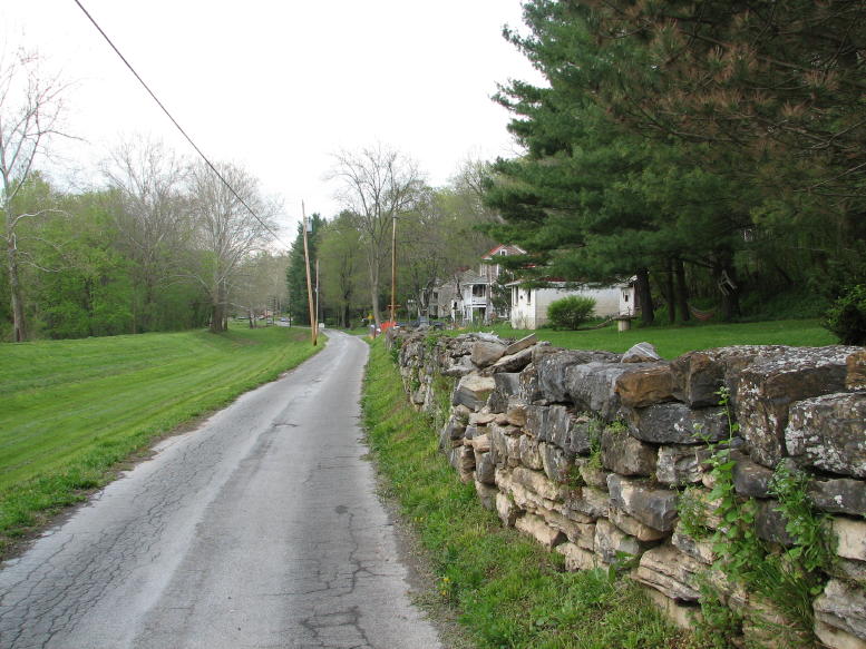
Next stop was Williamsport, MD. Many of the roads that run alongside the C & O Canal are narrow little numbers like this one:
Image


At Williamsport, there's the Cushwa Warehouse and Basin on the Canal. Nearby are the remains of the aqueduct that carried the Canal across Conococheague Creek. Apparently it's fairly common for the upstream wall of such aqueducts to wash away first in floods. It provides a nice "cutaway" look at how the aqueduct was constructed.
Image
Image


Not far outside of Williamsport, I re-found this beautiful little waterfall. It's located in the backyard of an older, and very attractive, home. Just the place to spend relaxing afternoons and evenings. Maybe even mornings...
Image


I had been on Dam No. 5 Road before, but only as far as the dam itself. This time, I was in search of the "ghost town" of Two Locks mentioned in the Scenic Byways write-up, which lay "near the end of Dam 5 Road." Since I was going by the dam anyway, I thought it deserved another picture, this time from the hill above the lockhouse:
Image


Along the road, I found this house and a number of others in similar condition. While I suspected that this was the ghost town, my Washington County Map Book showed Two Locks as being farther down the road.
Image


Continuing to search, I soon found myself on Ashton Road, meaning that I'd gone too far. I turned around, located the teeny, driveway-looking road that I thought was the continuation of Dam No. 5 Road, and set off along it to find the true Two Locks. After passing by a few newer houses, I came to a farm where the road seemed to dead end. By turning around the barn, however, I found that it continued as a muddy, rocky "tractor trail" down a steep hill. Near the bottom, it deteriorated into this rock-strewn path, followed by a muddy bog:
Image


Deciding that discretion was the better part of valor, even on A Mighty GS, I chickened out and turned around. It was a good decision, since I later discovered that this was not, in fact, the extension of Dam No. 5 Road. Instead, I was on a farmer's private property! (Fortunately, the farmer and any of his shotguns were not on hand.) Of course, I still had to scrabble back up this hill, sneak back through the farm, etc., as part of my hasty retreat. (I know, I know: The Dude, Mike E., Tim, JVB, and the rest of the kool-aid gang would have thought nothing of it!) But, since I was on the wrong road, you all would have just ended up at the farmer's south 40 or whatever, and not at Two Locks...) At any rate, my search for the ghost town will have to resume on the next trip to that vicinity.
Image


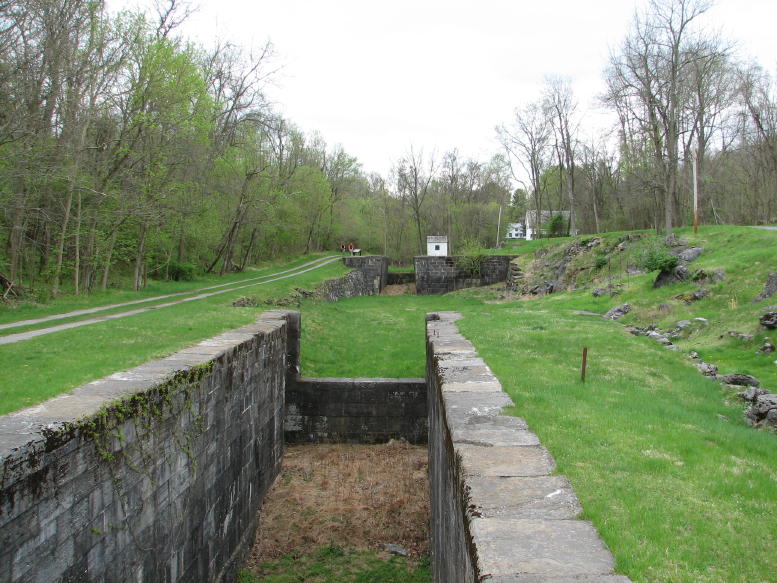
The Byways write-up recommended Four Locks on the C & O Canal as a worthwhile sidetrack, and it was right. First, there was this pretty view across a field:
Image


Then the four locks themselves were quite impressive. It was necessary to raise the canal boats 32 feet in a relatively short distance, thus requiring the series of locks. This shot looks back from Lock 49 to Lock 50:
Image


Oh yes, time for a motorcycle picture, in this case parked near Lock 50:
Image


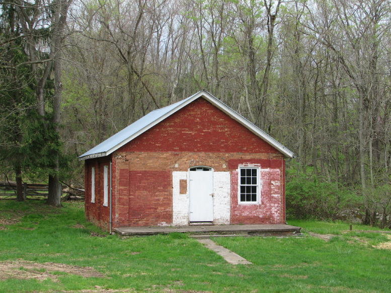
At one time, Four Locks was a thriving little community, and all the local children attended this one-room schoolhouse:
Image


From Four Locks, it was on to Hancock, MD, and then to Berkeley Springs, WV. As I and others have posted before, the view from the top of the mountain on Route 9, outside of Berkeley Springs, is too beautiful to pass up--and it clearly merits a picture:
Image


Now the real fun began. I'd ridden Route 9 before, so this time I took "Detour Road," which Google Maps had indicated as running back to Route 9 near Paw Paw, WV. While I love Google Maps, this time they lied!! Detour Road started off as a great little curving lane that ran up and over a mountain. Anyone know what these purple bushes are? They were everywhere and looked beautiful.
Image


After a dozen miles or more, Detour Road abruptly ended at Magnolia Road--and no indication of which way led to Paw Paw. My well-honed, intuitive sense of direction told me that I should turn left. That direction, however, soon appeared to lead up and back over the big mountain that I'd just crossed, so that didn't seem right. (Remember: No GPS, no detailed WV map, and an overcast day, so even East and West weren't apparent!) So, I turned around and headed back along the twisting roads in the opposite direction. At least it was fun riding!
Image


After 5 or 6 miles in the opposite direction, I encountered a "Dead End Ahead" sign. I turned around again, swallowed my pride, and stopped at the one house that I'd seen anywhere along the road. Remember, now, that this was the back hills of West Virginia. And while I detest stereotyping as much as anyone, this place had a certain "Deliverance" look to it... Lots of junked cars parked along the unpaved road to the house, ceramic nomes in the garden, a decidedly dilapidated look to the house itself, smoke from the chimney--and no one around nor a sound to be heard.

I parked the GS, took off my helmet, and walked to the front door, which was crooked on its hinges. I might have been humming the theme from "The Brave Little Toaster" to myself... Before I could knock, a huge fellow in bib overalls came to the door and looked sternly at me. I stammered out my question as to how to get to Paw Paw, while his eyebrows tilted farther and farther downward. Various kin started to congregate in the shadows just inside the door...

Okay, it actually turned out that he was quite a nice guy and very helpful (despite the fact that I'd woken him from a nap!) He said the "Dead End" direction turned to dirt and went to Paw Paw in 5 miles. The opposite direction was paved but was 8 or 9 miles. He showed me the mushrooms he'd picked that morning, described how to fry them in butter and sugar, asked about the BMW, and generally seemed glad to have some company.

After bidding him and his family farewell, I set off in the dirt direction, naturally, and soon found it. Initially the road was well packed and reasonably smooth:
Image


Eventually, however, after several miles, it turned into a rock-infested narrow path, followed by yet another Significant Bog. This is the point where (yet again) I decided to turn around and try the high road...
Image


At least on the way back, I spotted this colorful picture of a 1966 Chevy Biscayne and more of them purple things. (My wife Nancy just told me that it's an American Redbud, by the way.)
Image


Eventually, I ended up back on Route 9, just outside of Paw Paw. Following the Byways guide again, I turned on David Thomas Road and began the long dirt climb up the mountain and then back down to the town of Little Orleans, MD. By now (Mike), I could "hustle" the GS along such dirt roads at 30 mph or so without feeling too out of control, and there were lots of pretty spots along the way for more pho op's.
Image
Image


Reaching Little Orleans after a good 15 miles or more of dirt-tracking, I found Bill's Bar and The General Store. That's all there was left of the town! That and a few fisherfolk:
Image


Nearby, however, was the C & O Canal aqueduct over 15 Mile Creek. It was in pretty good shape:
Image


Some of you will remember from an earlier ride report how I was run off a property by a zealous Girl Scout. This time, I suffered the indignity of having to wait for a lengthy group of Cub Scouts to cross the aqueduct before I could return. Sigh ... is there no hope for us motorcyclists any more? We get "Wild Hogs" instead of "The Wild One." Just ain't the same!
Image


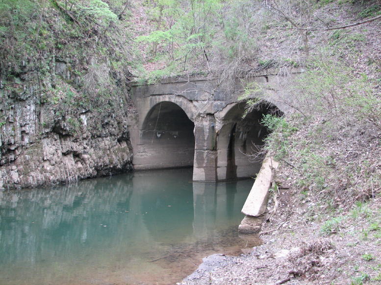
Now, here's the real mystery. About 100 yards upstream on 15 Mile Creek, the creek goes through an obviously man-made tunnel. There's no aqueduct on top of the tunnel, no train tracks (except maybe way up the ridge, nor any other reason for anyone to build a tunnel there that I could see. Can anyone provide the answer? (A friend at work said it must be a Revolutionary War Tunnel of Love...)
Image


Okay, Tina--I found a nice river to park the GS next to for a picture! (The confluence of 15 Mile Creek on the right and the Potomac in the background, in this instance.)
Image


By now it was getting late. I had planned to return down the dirt road to Paw Paw and move on to Oldtown, but that was before I realized the dirt road was 15 miles or more long. Consequently, I decided to go north, instead, toward Interstate 68--but I had no idea how to get there. My not-so-detailed Maryland map seemed to indicate that almost any road out of Little Orleans would work (and there were only two). My first attempt, of course, ended in another Dead End. (I really wanted a GPS by then!)
Image


For once, however, my vaunted sense of direction managed to take me in a correct (and visually interesting) shortcut back to Little Orleans. After that, the second choice of roads worked and sped me up to 68 without problems.
Image


I putted on home via 68, 40, and 70--mostly in a light rain. With my helmet vents closed, heated grips and jacket liner turned on, and rain gear on, I was quite comfortable. Best of all, I'd had a terrific trip and a series of adventures. (Although, as a friend of mine likes to say, "Adventures suck when you're having them!") In truth, I enjoyed mine without question.

All told, it was 288 miles and about 10 1/2 hours of exploring. Even the rain didn't dampen the fun. Sorry you and Walt couldn't join the trip, Kitty, but I hope you had a fun time in Virginia. As always, if anyone is interested in the exact route, just let me know.

Rick F.
Last edited by Rick F. on Sun Sep 13, 2015 2:06 pm, edited 2 times in total.
For all my tour articles, check out rsftripreporter.net.

2020 Mercedes-Benz SL550
2013 BMW 335i convertible (sold)
2007 Aston Martin V8 Vantage (sold)
2006 BMW Z4 3.0i roadster (sold)
2005 BMW R1200GS (retired)
2003 BMW F650CS (sold)
User avatar
Rick F.
Board Wizard
 
Posts: 1734
Joined: Sun Jul 31, 2005 5:43 pm
Location: Catonsville, MD

Postby JimVonBaden » Tue May 01, 2007 10:05 pm

Your pictures are proof that lost can be good!

Outstanding once again! You have a gift for photography, and for finding great subject matter!

Jim 8)

PS Check the general section for cheap GPS units.
User avatar
JimVonBaden
Smooth Motorcycle Operator
 
Posts: 17669
Joined: Tue Oct 28, 2003 11:48 pm
Location: Alexandria, VA

Postby Unity » Tue May 01, 2007 11:32 pm

Nice, Rick. Looks like a fun day, socially as well as scenically. :wink:

Be forewarned, GPSs almost always know where they are, but they don't always know if there are any roads to or from where they are. I've looked with consternation many times at the little "your vehicle is here" symbol out in the middle of uncharted space. But GPSs are usually great for getting you unlost. If nothing else, just tell it "Home." :)

--John 8)
2002 R1150RT, Silver
Silver, the "cool and aloof" color.
(Road & Track Vol. 56, No.2, p. 19)

1971 Triumph Bonneville, Gold
Gold, the "paying the restorer" color.
(Trust me.)
User avatar
Unity
Shaman
 
Posts: 7170
Joined: Fri Sep 17, 2004 11:26 am
Location: Reston VA

Postby Graybeard » Wed May 02, 2007 6:57 am

JimVonBaden wrote:Your pictures are proof that lost can be good!

Outstanding once again! You have a gift for photography, and for finding great subject matter!

Jim 8)

PS Check the general section for cheap GPS units.


+1

Thanks, yet again, for sharing, Rick!
Larry
Germantown, MD
'06 R12RT, MD 0011 BMR
'16 S1000XR, MD 0052 BMR
User avatar
Graybeard
Board Guru
 
Posts: 887
Joined: Mon May 15, 2006 9:55 pm
Location: Gaithersburg MD

Postby DogHouse » Wed May 02, 2007 7:14 am

Fantastic Rick. Another great ride report.
BTW the purple shrubs are Redbud trees. A native understory tree. They can be bought at any nursery.
Image

05 R1200GS
97 Craftsman 19hp Riding Mower 42" cut
User avatar
DogHouse
What? Again? Oy
 
Posts: 7219
Joined: Mon Jul 12, 2004 10:19 am
Location: State of Confusion

Postby RocketMan » Wed May 02, 2007 11:44 am

But but but......

why woulod you NOT want to get lost?????

that's half the fun of such rides!

great report as always...

maybe I should get a GS?......


Naw, too heavy......... :lol:


RM
Fromerly MR. MonkeyButt now Mr. Breezy-Butt!
http://roadrunes.com

"Everyone is entitled to his own opinion, but not his own facts" - Daniel Patrick Moynihan

"I think you're a NUT!"- Tina
User avatar
RocketMan
Board Wizard
 
Posts: 4578
Joined: Tue May 11, 2004 1:58 pm
Location: State of Confusion

Postby DiscoPete » Wed May 02, 2007 2:45 pm

That was another great ride report, Rick.

The tunnel that you were wondering about is the Paw Paw Tunnel, "a 3,117 foot passage through Anthony Ridge". It was built to avoid two bends in the river. It took 14 years to complete and it and was the last part of the canal to be completed. (That information is on Page 115 of the link you provided at the beginning of the article).
-Pete
User avatar
DiscoPete
Board Guru
 
Posts: 766
Joined: Fri Aug 01, 2003 1:05 pm
Location: Anne Arundel county, Md.

Postby Rick F. » Wed May 02, 2007 9:51 pm

JimVonBaden wrote:Your pictures are proof that lost can be good!

Outstanding once again! You have a gift for photography, and for finding great subject matter!

Jim 8)

PS Check the general section for cheap GPS units.

Jim,

Thanks--both for the compliment and for the link to the $265 Garmin 2610. I'll check it out.

Rick F.
For all my tour articles, check out rsftripreporter.net.

2020 Mercedes-Benz SL550
2013 BMW 335i convertible (sold)
2007 Aston Martin V8 Vantage (sold)
2006 BMW Z4 3.0i roadster (sold)
2005 BMW R1200GS (retired)
2003 BMW F650CS (sold)
User avatar
Rick F.
Board Wizard
 
Posts: 1734
Joined: Sun Jul 31, 2005 5:43 pm
Location: Catonsville, MD

Postby Rick F. » Wed May 02, 2007 9:54 pm

Unity wrote:Nice, Rick. Looks like a fun day, socially as well as scenically. :wink:

Be forewarned, GPSs almost always know where they are, but they don't always know if there are any roads to or from where they are. I've looked with consternation many times at the little "your vehicle is here" symbol out in the middle of uncharted space. But GPSs are usually great for getting you unlost. If nothing else, just tell it "Home." :)

--John 8)

John,

It really was a fun day, despite the rain and not always having any idea where I was. Thanks for the tip regarding the level of map detail on a GPS. I can believe that these units wouldn't necessarily have every little WV backwoods road on them!

Rick F.

PS--In the bargain GPS post that Jim referenced, you mentioned that you thought the 2610 was actually better for motorcyclists than the newer Garmins. Can you elaborate (or should I check out existing posts)?
For all my tour articles, check out rsftripreporter.net.

2020 Mercedes-Benz SL550
2013 BMW 335i convertible (sold)
2007 Aston Martin V8 Vantage (sold)
2006 BMW Z4 3.0i roadster (sold)
2005 BMW R1200GS (retired)
2003 BMW F650CS (sold)
User avatar
Rick F.
Board Wizard
 
Posts: 1734
Joined: Sun Jul 31, 2005 5:43 pm
Location: Catonsville, MD

Postby Rick F. » Wed May 02, 2007 9:56 pm

Graybeard wrote:+1

Thanks, yet again, for sharing, Rick!


Larry,

Thanks. I really enjoying putting the pictures up and getting reactions from folks. It's also fun to sort through all the pictures from a trip, to pick out the best 10-15 of them to use in the write-up. (Although, lately, I've been tending toward a slightly higher count.)

Rick F.
For all my tour articles, check out rsftripreporter.net.

2020 Mercedes-Benz SL550
2013 BMW 335i convertible (sold)
2007 Aston Martin V8 Vantage (sold)
2006 BMW Z4 3.0i roadster (sold)
2005 BMW R1200GS (retired)
2003 BMW F650CS (sold)
User avatar
Rick F.
Board Wizard
 
Posts: 1734
Joined: Sun Jul 31, 2005 5:43 pm
Location: Catonsville, MD

Postby Rick F. » Wed May 02, 2007 9:59 pm

DogHouse wrote:Fantastic Rick. Another great ride report.
BTW the purple shrubs are Redbud trees. A native understory tree. They can be bought at any nursery.


DogHouse,

Thanks. Your identification of the American Redbud confirms my wife's. They were just everywhere on the trip in Western Maryland and Northeastern West Virginia.

Rick F.

PS--Nancy tells me that we have one in our side yard. So much for my astute powers of observation!
For all my tour articles, check out rsftripreporter.net.

2020 Mercedes-Benz SL550
2013 BMW 335i convertible (sold)
2007 Aston Martin V8 Vantage (sold)
2006 BMW Z4 3.0i roadster (sold)
2005 BMW R1200GS (retired)
2003 BMW F650CS (sold)
User avatar
Rick F.
Board Wizard
 
Posts: 1734
Joined: Sun Jul 31, 2005 5:43 pm
Location: Catonsville, MD

Postby Rick F. » Wed May 02, 2007 10:03 pm

RocketMan wrote:But but but......

why woulod you NOT want to get lost?????

that's half the fun of such rides!

great report as always...

maybe I should get a GS?......


Naw, too heavy......... :lol:


RM


RM,

Well, I have to admit that you have a good point. "Discovering" new and interesting back roads is what I like the most about motorcycling. Getting lost is an excellent way to do that. After 6 hours of riding and exploring, however, getting lost to the point of having no idea which way to go seemed just a bit frustrating--I didn't want to waste any of the time I had left for exploring. Still, the adventure took me into the heart of Appalachia, and I learned how to fry weird white mushrooms with little bumps on them... It looked like a miniature Christmas tree!

Rick F.
For all my tour articles, check out rsftripreporter.net.

2020 Mercedes-Benz SL550
2013 BMW 335i convertible (sold)
2007 Aston Martin V8 Vantage (sold)
2006 BMW Z4 3.0i roadster (sold)
2005 BMW R1200GS (retired)
2003 BMW F650CS (sold)
User avatar
Rick F.
Board Wizard
 
Posts: 1734
Joined: Sun Jul 31, 2005 5:43 pm
Location: Catonsville, MD

Postby Rick F. » Wed May 02, 2007 10:09 pm

DiscoPete wrote:That was another great ride report, Rick.

The tunnel that you were wondering about is the Paw Paw Tunnel, "a 3,117 foot passage through Anthony Ridge". It was built to avoid two bends in the river. It took 14 years to complete and it and was the last part of the canal to be completed. (That information is on Page 115 of the link you provided at the beginning of the article).

DPete,

Thanks for the thought regarding the Paw Paw C & O Canal tunnel. As it happens, I've been there (see http://www.bmwbmw.org/bmwforums/viewtopic.php?t=5543), and this wasn't it! At the Paw Paw tunnel, the canal itself runs through the tunnel and it has a towpath alongside it. On 15 Mile Creek, the creek runs through the twin-tunnel, no canal (which crosses the creek 100 yards downstream) and no towpath.

Any other thoughts?

Rick F.
For all my tour articles, check out rsftripreporter.net.

2020 Mercedes-Benz SL550
2013 BMW 335i convertible (sold)
2007 Aston Martin V8 Vantage (sold)
2006 BMW Z4 3.0i roadster (sold)
2005 BMW R1200GS (retired)
2003 BMW F650CS (sold)
User avatar
Rick F.
Board Wizard
 
Posts: 1734
Joined: Sun Jul 31, 2005 5:43 pm
Location: Catonsville, MD

Postby JimVonBaden » Wed May 02, 2007 10:54 pm

Rick F. wrote:
RocketMan wrote:But but but......

why woulod you NOT want to get lost?????

that's half the fun of such rides!

great report as always...

maybe I should get a GS?......


Naw, too heavy......... :lol:


RM


RM,

Well, I have to admit that you have a good point. "Discovering" new and interesting back roads is what I like the most about motorcycling. Getting lost is an excellent way to do that. After 6 hours of riding and exploring, however, getting lost to the point of having no idea which way to go seemed just a bit frustrating--I didn't want to waste any of the time I had left for exploring. Still, the adventure took me into the heart of Appalachia, and I learned how to fry weird white mushrooms with little bumps on them... It looked like a miniature Christmas tree!

Rick F.


That is the best use for a GPS.

Ride until you are ready to go home with no fear of messing around being lost trying to find your way, and ruining a perfectly good day with frustration.

I use mine for much more, but this works too!

Jim 8)
User avatar
JimVonBaden
Smooth Motorcycle Operator
 
Posts: 17669
Joined: Tue Oct 28, 2003 11:48 pm
Location: Alexandria, VA

Postby Unity » Wed May 02, 2007 11:33 pm

Rick F. wrote:In the bargain GPS post that Jim referenced, you mentioned that you thought the 2610 was actually better for motorcyclists than the newer Garmins. Can you elaborate (or should I check out existing posts)?

The software in the 2610 is different from the software in the newer units. The newer ones are more intuitive and quicker to program for finding things -- towns, addresses, points of interest. (I mean, the first interface screen says, "Where To?") It's nice that they auto-complete when you've put in enough letters to narrow down a town name, for instance, where the older software requires you to spell out the whole name. And the newer ones make finding a hotel or a restaurant easier, even offering to dial up the place for you if you've got your cell phone hooked in. The newer ones have a "3-D" default for the map display, so it's sort of like you're looking at your near route in perspective -- "there, up there on the right, that's where I turn," and the display always points the way you're going. They can also be set to display in old-fashioned 2-D map orientation like the 2610 (which I prefer because it's easier to see more of the total route, and you can leave north in its usual place, but then I'm old and old-fashioned).

Where I really find myself appreciating the 2610 is in route selection. I have our 2610 pretty well dialed-in for road preferences, which can be weighted on sliding scales by percentage, e.g., 70% minor roads, 80% secondary roads, 50% major roads. The newer ones have their preference settings as off/on switches -- avoid/don't avoid. So if you tell it not to avoid any type of road, it's free to route any which way. And it will.

The other thing that seems to be the same, but isn't, is Garmin's crazy faster route/shorter route dichotomy. Our 2610 will route us far more sensibly, whether we pick speed or distance, than our 2730 will. For example, a couple of weeks ago we had been downtown and were just heading home on I-66 when I noticed that we needed gas. I got off at the first opportunity and filled up. While I was doing that, Jody fiddled with the 2730 and told it to take us "Home." Unfortunately, the preference was set on shorter route. On cyberadvice, we abandoned I-66 and its promise of the Dulles Toll Road and headed off through darkest Arlington by way of small neighborhood streets, eventually making it to the small streets of Great Falls, and finally to the Dulles Toll Road. As we proceeded I figured out that we were following the route closest to a straight-edge-scribed line between Point A and Point B. Garmin really should refine that time/distance thing. There's almost always a third or fourth possible choice entering into a real-world decision.

I got the 2730 thinking that for trips I'd like the XM radio with the NavTraffic and WX Weather options, and I probably will. (I haven't figured out yet whether I can direct XM plus the Garmin's voice through the AutoComm, but I'm hoping so.) I expect the 2730 is going to require me to pay more attention to maps, and to look for places where I should intervene and override the program, than has been the case with the 2610. Not that the 2610 doesn't make weird selections at times.

It seems to me that the newer software is more car-friendly, i.e., made for transportation appliances in which the destination outweighs the experience.

--John 8)
(I'm sure I've missed some things. Ray? What else should Rick know?)
2002 R1150RT, Silver
Silver, the "cool and aloof" color.
(Road & Track Vol. 56, No.2, p. 19)

1971 Triumph Bonneville, Gold
Gold, the "paying the restorer" color.
(Trust me.)
User avatar
Unity
Shaman
 
Posts: 7170
Joined: Fri Sep 17, 2004 11:26 am
Location: Reston VA

Next

Return to Ride Stories

Who is online

Users browsing this forum: Google [Bot] and 24 guests

cron