If I may offer a little geological and (very little)
historical context--
On one of my early Fort Valley rides, I started wondering what kind of valley I was riding through. The stream is way too small to be the mechanism for its formation. And why is it called Fort Valley?
Fort Valley between the exposed flanks of the Massanutten Mountain syncline,
in the Shenandoah Valley between the Blue Ridge and West Virginia
http://www.virginiaplaces.org/geology/topo.htmlAbout Fort Valley, Wikipedia wrote:Fort Valley is a mountain valley in Shenandoah County, Virginia. The so-called "valley within a valley" lies between the two arms of the northern Massanutten Mountain range in the Shenandoah Valley. The valley is closed at both ends (except for a very narrow gap at the northern end through which Passage Creek flows and a single road, S.R. 678, runs) but opens out as one moves toward the center, becoming about three miles wide at its widest. In all, Fort Valley is 23 miles long.
Roads exit the valley at Edinburg Gap (S.R. 675) towards Edinburg, Moreland Gap (S.R. 730) towards New Market and Edith Gap (S.R. 675) towards Luray. There is also a dirt road that leads to Woodstock (S.R 758) over Powell Mountain. The valley is mostly rural, consisting of private farmland, surrounded by the George Washington National Forest, which covers the slopes on both the east and west mountains. The Elizabeth Furnace and Camp Roosevelt Recreation Area of the G.W. Forest are located within Fort Valley.
According to tradition, Daniel Morgan built the first road into Fort Valley from the north, at the order of George Washington, with a view to holing up in this naturally fortified valley as a possible last stand against the British during the American Revolution. The Continental Army's victory at Yorktown altered Washington's plans.
About Massanutten Mountain, Wikipedia wrote:The mountain bisects the Shenandoah Valley just east of Strasburg in Shenandoah County in the north, to its highest peak east of Harrisonburg in Rockingham County in the south.
The mountain is divided into northern and southern sections, divided by the New Market Gap. The northern section consists of 3 roughly parallel ridges, forming 2 valleys. The wider, main valley, is called Fort Valley, while the smaller one is known as Little Fort Valley. The ridges of the northern section converge at New Market Gap. The southern section consists of a series of closely gathered ridges, separated by precipitous creek gorges.
On the eastern side of the mountain range lie the Page Valley and the Blue Ridge Mountains. On the western side lie the North-Central Shenandoah Valley and the Great North Mountain of the Alleghany Mountains.
Geology of Virginia / Valley Ridge wrote:The structure of Massanutten Mountain is that of a geologic syncline. The northern part of the mountain has a central valley formed on softer Devonian shales preserved in the central part of the syncline.
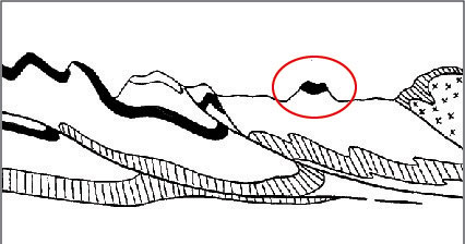
Massanutten Mountain is an example of inverted topography. The mountain has formed on a syncline, as shown circled in the cross-section above. A lowland has formed in the center of the syncline....
http://www.radford.edu/jtso/GeologyofVi ... ocationMap
Remember synclines and anticlines from Geol. 101?
Geology of Virginia / Structures wrote:Anticlines and synclines are the up and down folds that usually occur together and are caused by compressional stress.
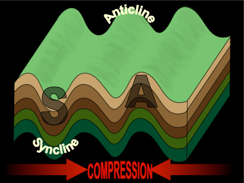
Anticline and syncline (Diagram by Phyllis Newbill)
Anticlines are folds in which each half of the fold dips away from the crest. Synclines are folds in which each half of the fold dips toward the trough of the fold. You can remember the difference by noting that anticlines form an “A” shape, and synclines form the bottom of an “S.”
http://www.radford.edu/jtso/GeologyofVi ... s4-2e.html
Compressional forces are a whole different subject.
A blogger who lives in Fort Valley (hence "home") posted this cross-section:
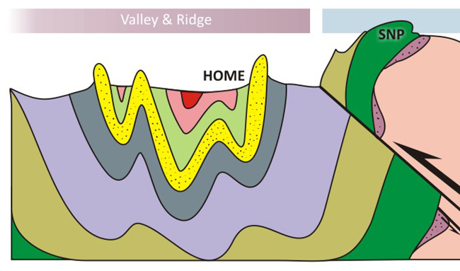
Finally, this shows Front Royal and Luray for spatial reference, along with dashed lines that illustrate, I think, the parallel nature of the Massanutten Synclinorium and the Blue Ridge Anticlinorium. I found this diagram some time ago and I don't remember its source, nor do I find it googling images. My apologies to the originators for not crediting their work.

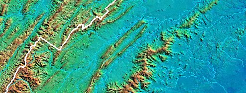
Jeff, you rode down part of the Massanutten Mountain syncline, maybe 40% of it, and crossed over the east ridge of Massanutten Mountain into Page Valley. Just guessing, you may then have crossed the Blue Ridge anticline via Thornton Gap.
--John


