Washington County lies to the west of South Mountain. It was created as a separate county in September 1776, when many families chose to settle here after the conclusion of the French and Indian Wars.
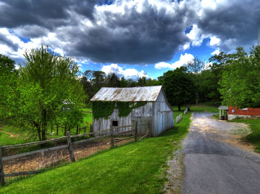
I spotted this slightly ramshackle house on the other side of South Mountain from Burkittsville, MD (where The Blair Witch Project was filmed). What do you keep on your front porch?

Harper’s Ferry Road is a great way to get from Sharpsburg, MD to Harper’s Ferry, WV (or vice-versa). In the village of Antietam—not to be confused with Sharpsburg, where the Battle of Antietam was fought—one finds what’s left of the Antietam Ironworks. This furnace dates back to 1775 and was used to produce cannon for the American Revolution. It continued in operation through the late 1800s.


I’d seen the furnace before—in fact, as much as 50 years ago—and nothing had changed except for a pair of faux locomotives parked at one end. After a quick look, I realized that these are barbecue smokers, dressed up to look like steam engines. In practice, they’re towed to wherever they’re needed behind a pickup.

By chance I spotted some stone ruins off in the woods on the other side of the road. A couple of passing ladies told me that there used to be a dam and race for the iron furnace, fed by nearby Antietam Creek.

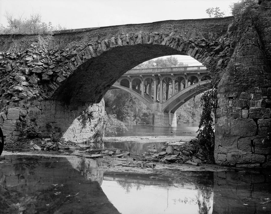
Although sorely tempted to investigate further, the path I would have to take was under several feet of water! Thanks to heavy rains the prior 2 days, the Antietam was well and truly flooded. Compare this photo of the 1832 Antietam Ironworks Bridge on the day of my visit to the one by John Gensor, which shows the bridge at normal water levels. (John has a very interesting history of this area at Antietam Ironworks Bridge 1832.)


My intention was to next take Canal Road to the Route 34 bridge over the Potomac River. This part of the former Chesapeake & Ohio Canal is normally dry, but the rain had managed to partially fill it back up.

As for Canal Road, I was happily driving along, minding my own business and enjoying the lush vegetation, when I happened to notice that the reflections of the trees and shrubs were beginning to take over the road. With my usual sharp wits and incisive powers of deduction, it eventually dawned on me that the road was completely flooded. Exercising either good judgment or excess timidity (your choice), I turned around and found an alternative route.

In the back of my mind was awareness of what happens when water reaches the level of an engine’s air intake system: namely, it gets sucked into the cylinders, where the rising pistons try to compress it, only to discover that, unlike air, water doesn’t compress. Bent connecting rods are the usual outcome. (I like to think that my 335i’s engine thanked me for having turned around.)
I crossed over the Potomac River at Shepardstown, West Virginia and went searching for the ruins of the Potomac Mills on River Road. Although the Potomac was also quite flooded, the water had receded below road level, leaving only some muddy residue. The mills’ office building was mostly high and dry.

The mill complex was built in 1826 and originally used to grind wheat before being converted 3 years later to produce hydraulic cement. Such “natural cement” hardens in water and remains watertight; it was in great demand for constructing the C&O Canal, and Potomac Mills was one of the largest producers in the canal area. The complex was burned by Union troops in August 1861 and damaged further during the “Battle of the Cement Mill” when Robert E. Lee’s Confederate Army escaped back across the Potomac at this location, following Antietam. At various times during the battle, both Union and Confederate forces took shelter from enemy fire in the mills limekilns. Remarkably, the mill was rebuilt by 1875. Over the years, various floods damaged the facility, and it ceased operations in 1901. The ruins live on, however. This was part of the main mill building. Its stone first story has remained fairly intact, but the upper three brick stories are long gone.

The Potomac was still well out of its banks, despite having dropped at least 6 to 10 feet by the time I arrived. After taking these two photos, I realized that my feet had sunk quite a ways into the muddy ground, and it was a bit of a struggle to get free! (And cleaning my shoes before getting back into the pristine 335i took at least 20 minutes.) The second photo below, incidentally, shows part of the race wall that directed water to power the grinding stones.


Back in Shepherdstown, I stopped for a brief look at the old railroad station, which is now (sigh) a dentist’s office.

I was searching for another riverside vantage spot and in the process rediscovered the 1800 Mecklenburg Warehouse. It originally served as a tobacco inspection facility and later as a warehouse for local crops being shipped to Washington, DC. In the lower right corner of the photo is a Shepherdstown University history professor and his family. He happily told me quite a bit about the ferry landing and associated businesses that used to stand at this location. The warehouse is the only remaining intact structure and is visible on the far side of the river in the historical photo below, at center. It has been stabilized and partially renovated following a long period of deterioration. (Historical and warehouse renovation photos courtesy of Friends of the Shepherdstown Riverfront.)


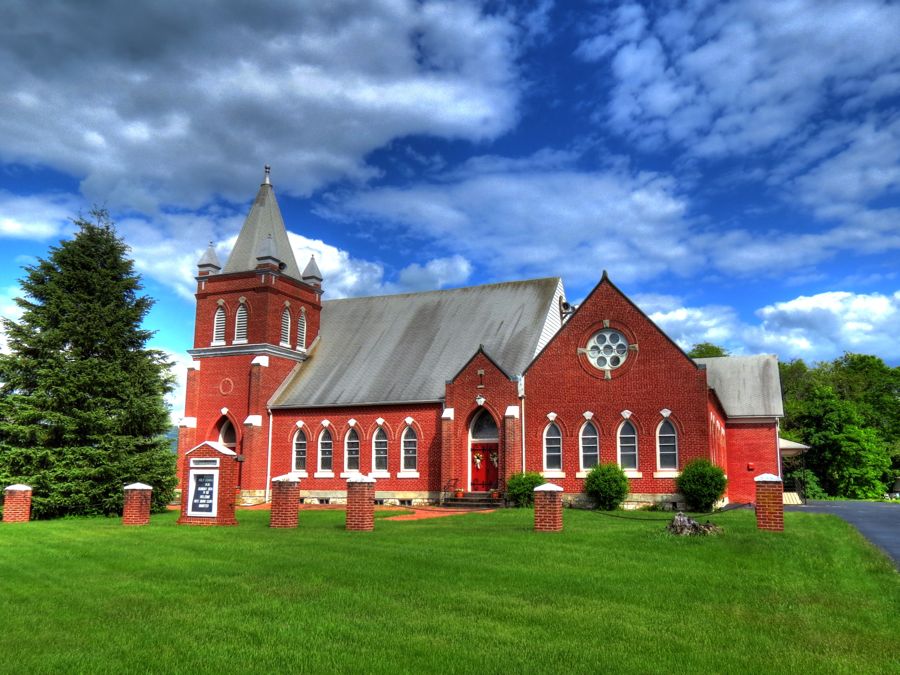
Crossing back into Maryland, I soon located Tolson’s Chapel in Sharpsburg. It was built by the town’s freed African Americans shortly after the Civil War, with John R. Tolson serving as its first minister. Two years later, a Freedmen’s Bureau school for African American children was established here, despite opposition from the town’s white residents. The school continued for 33 years, at which time the Washington County School Board finally built the first public school for the black community in Sharpsburg. The chapel closed in 1994 when the congregation had dwindled to only 2 members. Beneath the plank siding, the church is constructed of logs. (As always, historical photos are courtesy of the Library of Congress unless otherwise identified.)


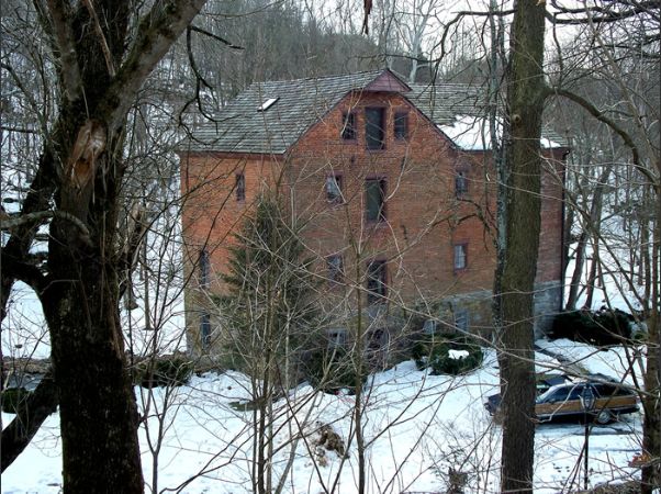
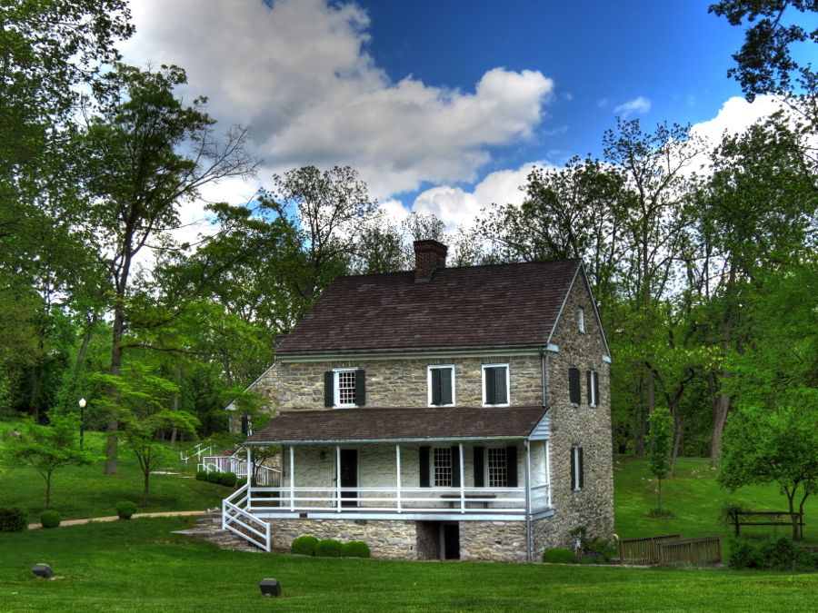
Outside of Keedysville, MD, I found the home of Samuel and Barbara Hitt without difficulty—but I couldn’t see any sign of the 5-story Hitt’s Mill. The house, like Tolson’s Chapel, is made of logs and is one of the largest such houses in the state. It is believed to have been built in the late 1700s or early 1800s, with the original mill following in 1820. The current mill building, shown in Robert Kinsey’s photo from MillPictures.com, was constructed in 1850 by new owner Samuel Pry. Both the house and mill were used as makeshift hospitals following the nearby Battle of Antietam. The mill continued to operate until 1926.
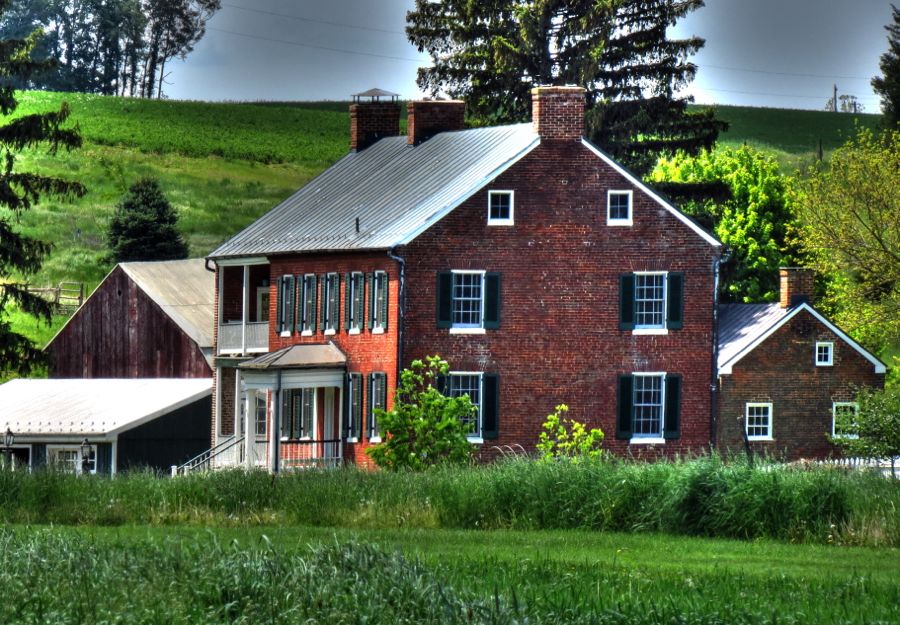
Sometimes this is as close as you can get to a site without Well-Intended But Grossly Willful Trespassing. Although I’m guilty of such trespasses from time to time, on this occasion I resorted to the 40x zoom lens on my camera for a closer look. The Hoffman Farm from about 1840 is one of the best-preserved old farms in Maryland. Although Maryland farmers often owned slaves before abolition in 1864, very few slaves’ quarters have survived. The smaller brick building to the right of the Hoffman house is one of only six such structures remaining in the county. Like the Hitts’ property, the Hoffman farmhouse and other buildings were all used as hospitals for more than a month following Antietam.

Did I mention what a beautiful day it was? Temperatures in the high sixties, no sign of rain, but plenty of clouds to add texture and interest to the sky. And a variety of nicely paved back roads that encouraged the ever-willing 335i to exercise its 300 horses. (Say, is that a large intercooler lurking behind the lower grill? It’s the first time I’ve seen it!)

I detoured over to Dam No. 4 on the Potomac to get a further look at the flooding. Even at low water there is an impressive flow over the dam, and on this day it looked downright scary. I’ll admit to having thoughts of the millions of gallons of water undercutting the land where I stood, but the dam has remained intact since 1856, so I figured all was safe.


This “winch house” is perched over a feeder to the C&O Canal. There used to be mammoth wooden race gate underneath, which controlled the flow of water from the Potomac into this section of the canal.

From time to time when I stop for an old barn photo, I’ll have horses wander up looking for a handout. This was the first time that a cow did the same thing. (Yes, I pulled some of the tall grass from my side of the fence and fed it to her.)

Between Clear Spring and Hagerstown, I stumbled across the long-rumored VW Bus Burial Ground. By some natural instinct, aging VW Buses find their way here, either to die or to be renovated. Sacred ground indeed!

I was familiar with Conococheague Creek, which runs from Pennsylvania down through rural Maryland on its way to Williamsport and the Potomac River—but I’d never encountered the town of Conococheague. It’s located on the original National Road (now Route 40), which was first conceived by a young George Washington and eventually built in part along an old Indian trail surveyed in 1749-1750 by Delaware Indian Chief Nemacolin and one Thomas Cresap. The National Road prompted the development of many businesses, and Rufus Wilson founded Conococheague in the mid-1800s, building himself a stately home to go along with his post office and general store. It remains one of the most original rural settlements I’ve ever seen.
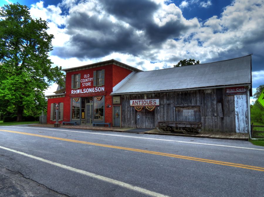
The general store wasn’t open on the Sunday that I visited, but I wish it had been.

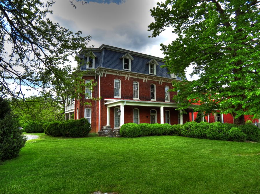
Rufus Wilson’s home was originally built of limestone in 1850 and expanded in 1880 with an outer covering of brick. The center portion of the house, in the second photo, shows a section of the original limestone.

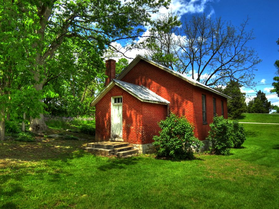
Rufus also built this one-room schoolhouse in about 1859 for use by his son and his neighbors’ children. It became part of Washington County’s school system in 1890 and continued in use until 1950—making it the last one-room schoolhouse operating in the county.
We’re not quite through with Rufus. The Wilson Bridge was named after him, and it carried the National Road traffic across Conococheague Creek from 1819 through 1936 when it was replaced by a concrete structure. The Wilson Bridge continued in local use until 1972, when it was damaged by flooding during Hurricane Agnes; in fact the entire bridge was underwater during the storm! After a partial collapse in 1982, the bridge was slated for demolition, but thankfully a public outcry led to its renovation as a historic landmark.


I grew up in Frederick, MD, which is about 35 miles from Hagerstown. Despite many trips there, I never noticed the stone home of Jonathan Hagar, who immigrated in 1736 from Westphalia, Germany. He soon met and married 15-year-old Elizabeth Kirschner, and they settled into this stone house. Sadly, Elizabeth died at age 40; Jonathan founded Elizabethtown in her honor in 1762, although the state legislature changed the name to Hagerstown in 1814.
“Hagar’s Fancy,” as his house was called, was built directly over two springs. They still flow freely, much to the delight of Herr und Frau Mallard.

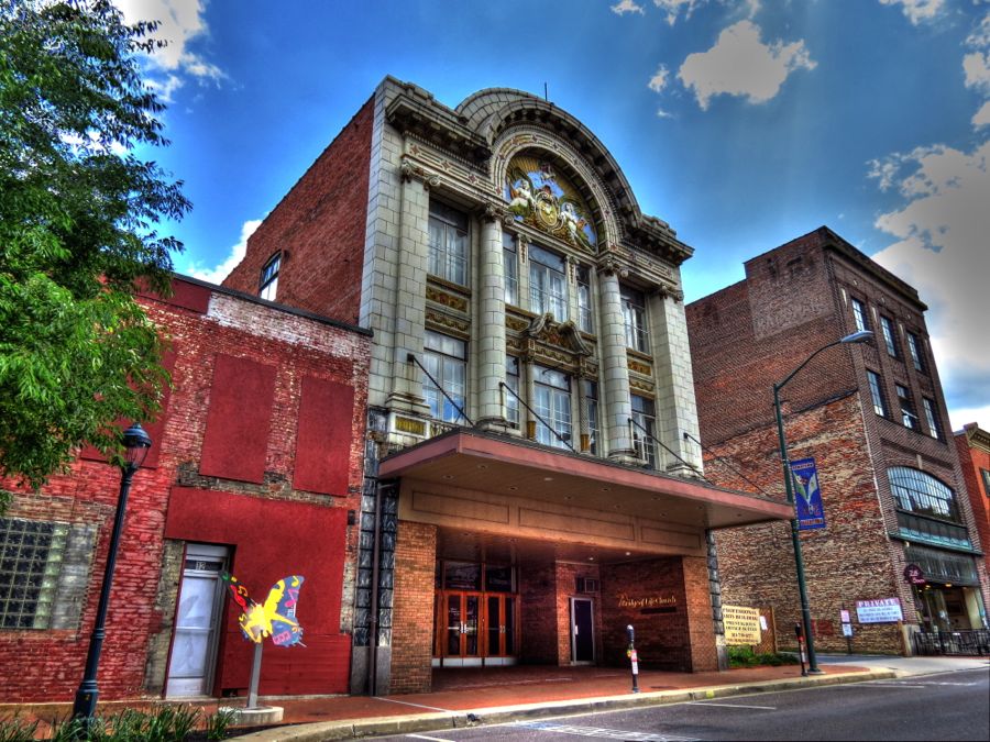
I vaguely remember going to see at least one movie at the Colonial Theatre in downtown Hagerstown. I do not recall being as impressed as I should have been by its over-the-top Baroque architecture. It was built in 1914 and continued in operation until 1975. As best I can tell, it is now home to the Bridge of Life Church, which probably does not sell the salty, old-style popcorn that I loved as a kid.
Remember Thomas Cresap? Over my years of touring, I’ve encountered him on a number of occasions, ranging from his fortified log house on the banks of the Susquehanna River in Pennsylvania to his trading post in Oldtown, Maryland. He was a notorious frontiersman and a “ring-tailed roarer,” bent on grabbing as much Pennsylvania land as he could and transferring it to Maryland. He so irritated his PA neighbors along the Susquehanna that they staged a raid on his house, captured him, and took him to court in Philadelphia—where Mr. Cresap declared to the judge that “Philadelphia is the grandest city in all of Maryland”! (The border disputes between the Penns of Pennsylvania and the Calverts of Maryland were not settled until the parties hired surveyors Charles Mason and Jeremiah Dixon in 1763.)
Following his trial and a period of imprisonment, Thomas Cresap was banished from Pennsylvania altogether. To my surprise, I learned that he next settled northeast of Hagerstown—and of course I had to see if anything remained of his new residence. He was granted 400 acres of land in this area in 1739, which he named Long Meadows. Cresap is believed to have built another fortified stone-and-log house here, over a spring near Marsh Run. (Having a built-in spring was a big advantage in the event of an attack by hostile Indians. Or hostile neighbors, for that matter…)
My initial passes by the Long Meadows area turned up nothing. I stopped to talk with a retired couple at their stately (but modern) house, and once again Good Touring Luck appeared: the couple turned out to be Mr. and Mrs. Dick Gruber, former owner of Gruber-Lattimer Restoration, LLC. Dick and his company restored literally hundreds of historic houses, churches, bridges, and other sites throughout the Mid-Atlantic area. His work included many of the buildings in Harpers Ferry National Park, the McClellan Gate at Arlington National Cemetery, the Mumma House and Barn at the Antietam Battlefield, and the Lincoln Speech Memorial at Gettysburg. They told me that stones from the ruins of Cresap’s Fort had been used to build a large stone barn near their own house. Only one wall of this barn remains standing, but local residents have kept it in good condition. They pointed the wall out to me, and I was there in moments. It’s not much, but it represents a noble monument to one of Maryland’s feistiest proponents from colonial days. Sadly, it appears that none of the three Cresap’s Forts remains in existence.

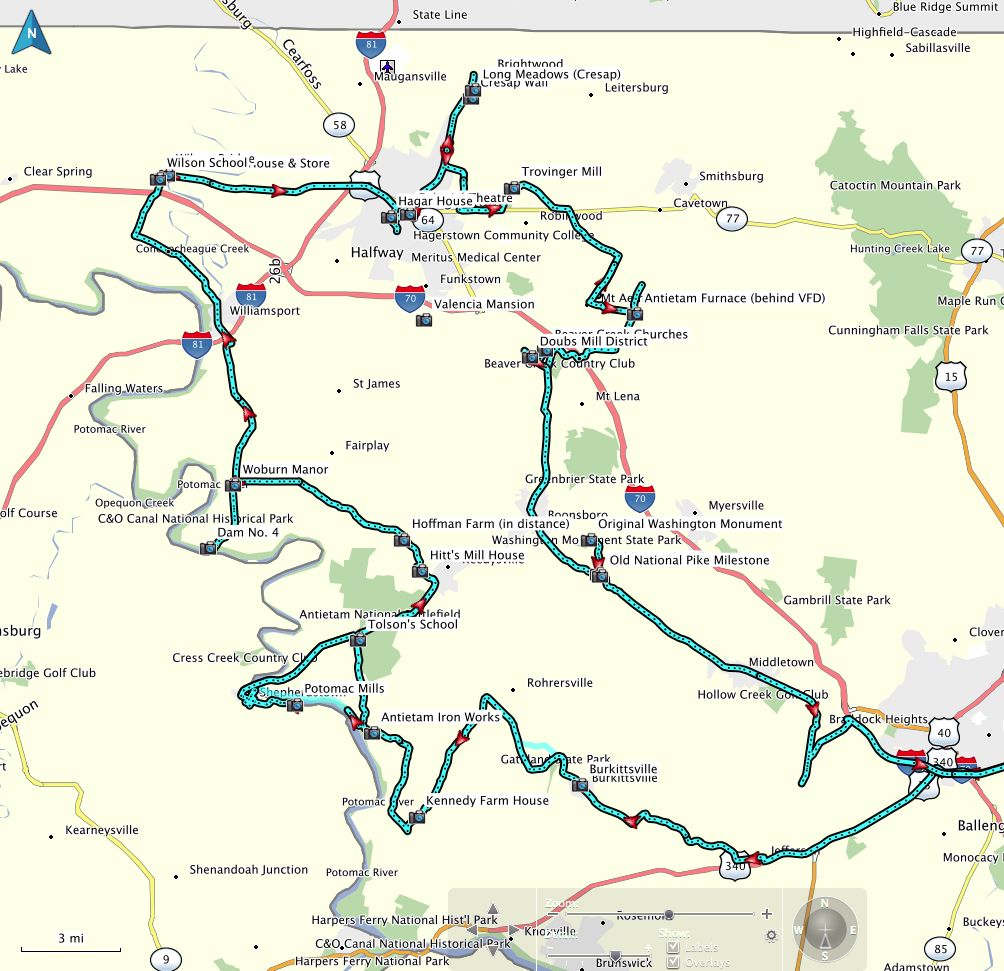
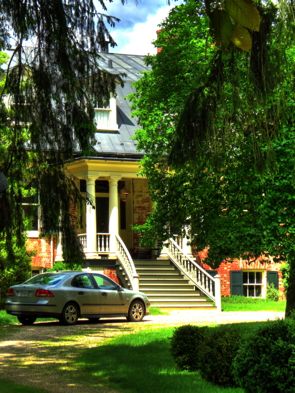
Dick also told me about a historic house just north of there, named Long Meadows. I found it without difficulty but could only see a small portion of it at the end of a long dirt drive. It was built sometime between 1835 and 1850, long after Thomas Cresap’s death, and has been extensively modified over the years. The original brick section remains largely unchanged, however, complete with its woodwork and doors. Here is my woefully inadequate photo, together with one from the Maryland Historic Archives:

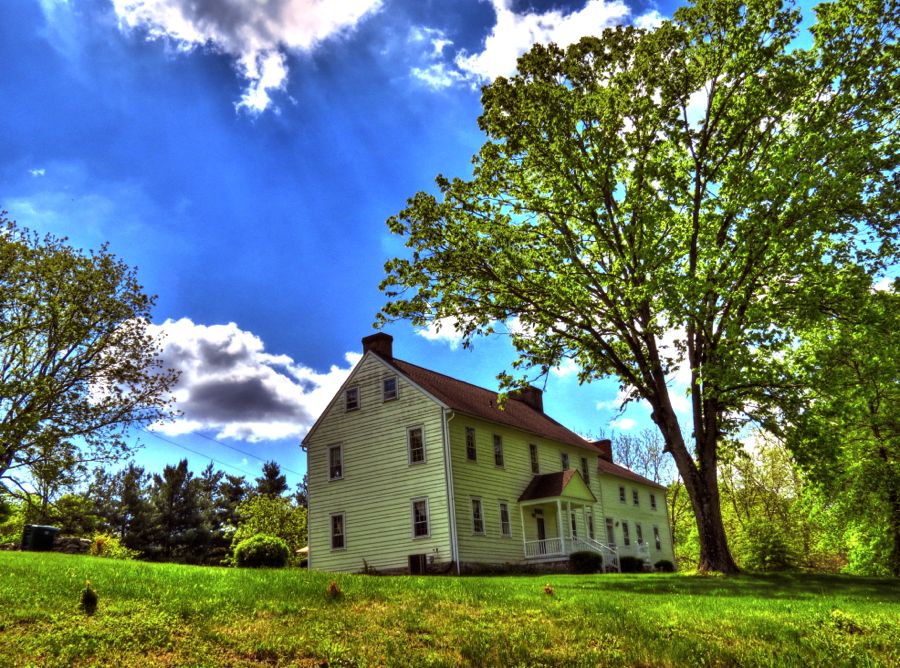
As I began to head back east and the general direction of home, I managed to find the Trovinger Mill along Antietam Creek. It was built in 1771 by Jacob Rohrer, with the millrace passing directly under the center section of the building. It is said to be little changed since its construction and to have much of its original milling equipment intact.

“Pop’s Garage” is not far from Trovinger Mill, and it looks to be a fun outfit. All of the hot rods, sportbikes, and cruisers parked there seemed to be for sale. The neighbors probably hate this place, but gearheads everywhere should be celebrating!

This “little house on the prairie” was situated all by itself, not far from a community center building. I have no idea who might have lived here or what its purpose might have been if it’s not a house. Sure was cute, though.

Washington County continues to have many small farms. This one appeared to still be active, with a significant number of newborn lambs frolicking all over.

As noted earlier, I’d known about the Antietam Ironworks for quite a long time. While planning this trip, however, I found a brief reference to an “Antietam Furnace archeological site.” I’d never heard of it, and, to add to the mystery, all of the references to the site indicated that its location was purposely withheld. Nonetheless, with a modest amount of work I learned that the furnace had been just behind the Mount Aetna Volunteer Fire Department—and had, in fact, been discovered in 1974 when the VFD was expanding its building. Archeological digs in 1982 found the remains of the furnace, water wheel pit, bellows hole, and casting areas, plus over 2,000 artifacts such as stove plates, cannonball, ceramics, glass, buttons, knives, and so forth. It represented one of the earliest centers of commerce west of South Mountain, as settlement of this area began to occur following the French and Indian Wars.
The Antietam Furnace was operated by the Hughes family and is believed to date back to 1768, which would make it the oldest iron furnace in the county. It apparently produced pig iron, stoves, cast iron pots and pans, other iron products, and cannon for the American Revolution. The furnace was used for only 7 to 10 years, with the Hughes shifting production to another, larger furnace nearby. I really wanted to find this “hidden” historical site.
I located the firehouse easily enough, parked, and walked back and forth behind it at least three times without finding a thing. So I tried scaling the steep banks immediately behind the building, still without seeing anything. Then I hiked over to the Mt. Aetna Creek, which I could hear a short distance away. I took a couple of photos of the small cascade there, but still no sign of an archeological site.


I tried hiking up the crude path away from the creek toward the top of the hill behind the VFD, without any luck. It was all kind of fun, although I wondered how long it might be before someone arrived to shoo me away. Eventually I headed back to the BMW. No evidence of the historical dig or the old furnace anywhere! My guess is that, after the excavation, everything got filled in again—possibly to prevent accidental injuries, vandalism, or just excessive wandering around by hapless historical picture-takers. It remains a mystery.

With hat in hand, I left the Mt. Aetna Volunteer Fire Department and went in search of the Doub’s Mill Historic District at Beaver Creek, MD—hoping that there would at least be something left of it. Along the way, I spotted Beaver Creek Church Road and detoured to see whether there might be a stately church there. Sure enough… The Beaver Creek Christian Church was built in 1845 by a group of former Baptists who opposed missionary efforts and split away to form the Disciples of Christ. (As my friends Kim and Cathy remind me, Baptists can be a feisty lot.)
Between 1833 and 1845, the Beaver Creek Disciples met in the Beaver Creek School. That building is long gone, however, having been replaced by this brick schoolhouse in 1904, which operated through 1971. It’s now a museum, owned by the Washington County Historical Society. The photo of the school museum’s interior, courtesy of the Frederick News-Post, shows the original furnishings and some rather scary-looking students and their teacher…


Immediately next door, St. Matthews Lutheran Church completed this triptych of historical buildings, all within a hundred or so feet of each other. My ad hoc detour had paid off nicely.
The Beaver Creek area dates back to a 1739 land grant from Charles Calvert, the fifth (and next-to-last) Lord Baltimore. The area was soon populated by German and Swiss Mennonite families with names like Newcomer, Funk, and Doub. These names were familiar to me, since I went to school in Frederick with a number of their descendants. Remember all the flooding from the prior days’ rain? Well, this photo shows half of Beaver Creek barely passing under a bridge. Only a few hours before, the road had been entirely flooded and closed to traffic.

The other half of Beaver Creek flows directly through Doub’s Mill, where it used to drive two large, internal, overshot mill wheels. The roar of the water descending through the mill was thunderous. Doub’s mill was converted to a residence in the 1980s by its current owners, Luigi and Mary Jane Perini. Mr. Perini’s exhaustive and quite interesting history of this area reports that Beaver Creek used to be one of the best places in Maryland for trout fishing, but apparently the stream’s vegetation was largely washed away by numerous floods over the years, and it is no longer capable of supporting trout. On the other hand, beavers have returned to Beaver Creek for the first time in more than 100 years and seem to be doing well. The stone gristmill was built sometime between 1811 and 1821 and operated through about 1940, with several modernizations and improvements to its machinery in the interim. It replaced an earlier wooden gristmill, which history reports became so loaded with grain that it split the gable apart, necessitating a desperate effort by the village to save the grain.


The old village comprises the mill, six houses, three barns, a couple of springhouses, and just one or two other buildings. Most are built of local limestone using a plain style typical of German immigrants in the late 1700s and early 1800s. This is “Homeplace,” which is located next to the mill. The oldest part of the house is in the back, possibly from 1791. The front addition has a cornerstone dated 1794.
The “Crickhollow Farm” sits on the other side of Beaver Creek and dates back to about 1790. Those German builders really knew what they were doing, given how well these houses have held up for 225 years! The house was owned by members of the Funk family from the early 1800s through 1966.

This house sits directly across the road from the Crick Hollow Farm house and is architecturally very similar, with its two stories, four bays, transom door, and offset entrance. Its appearance is much more weathered, however—which somehow made it my favorite among the Beaver Creek homes.

With last look at Beaver Creek, it was time to wrap up my tour with a quick jaunt to the top of South Mountain.

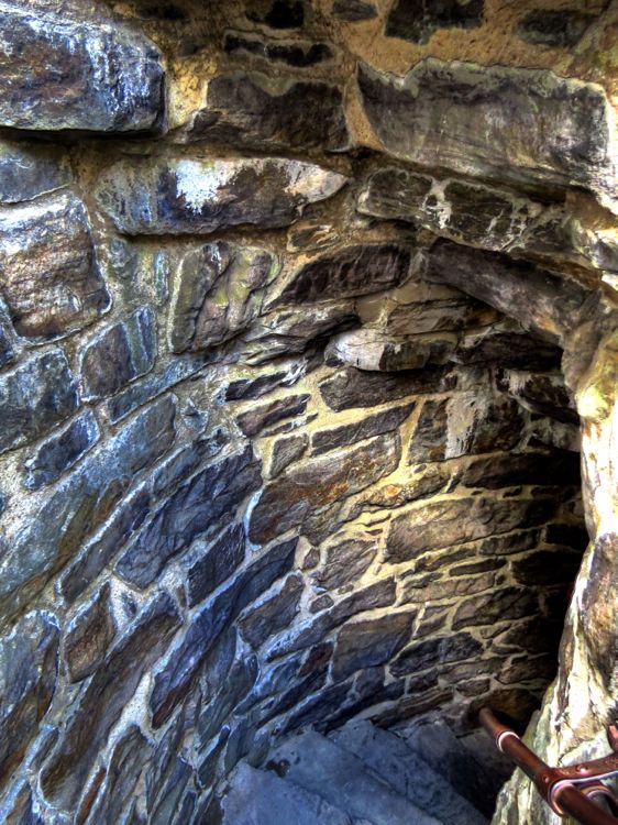
South Mountain divides Washington County from Frederick County, with the Appalachian Trail running directly along its summit. Pretty much everyone has seen or at least heard of the Washington Monument in the District of Columbia. However, few people realize that the very first monument in honor of George Washington sits at the top of South Mountain, having been built there in 1827 by the citizens of nearby Boonsboro, MD. (The Washington Monument in Baltimore was completed 2 years later, while the DC Washington Monument didn’t come along until 1885.) The original constructors apparently did not follow the sturdy building methods used by the German Mennonites of Beaver Creek, since the monument was mostly in ruins by 1880. But the town persevered and rebuilt it as good as new. A subsequent lightning strike caused a crack in the walls, leading to its collapse all over again; this time, the Civilian Conservation Corps stepped in and rebuilt it in 1936. I first visited here as a Cub Scout in the early 1960s, and the place has barely changed since then.
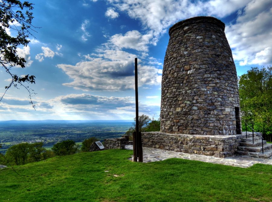
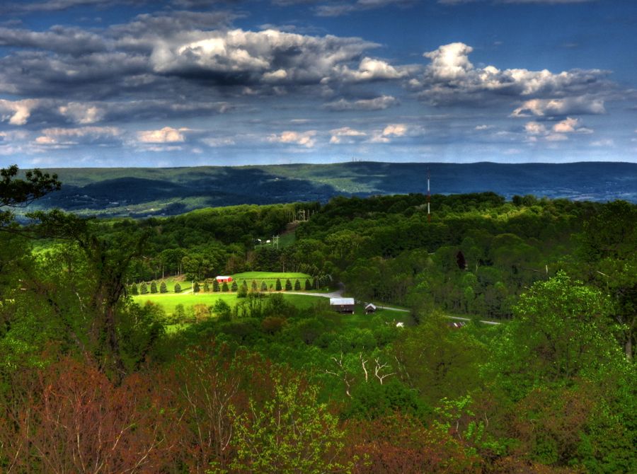
Getting to the top of the 40-foot-tall monument still requires negotiating a steep and very dark circular flight of steps, but the resulting view west from South Mountain is always well worth the effort.
These intrepid fellows began hiking the Appalachian Trail at its origin in Georgia and have covered approximately 1,000 miles—so far. On this day, they had traveled about 20 miles and were aiming for another 3 or 4 miles before camping for the night. They wisely rode out the prior day’s massive rainstorm in a motel!

The original National Road traverses South Mountain at Turner’s Gap, a few miles south of the monument. I was surprised (and pleased) to learn that one of the original stone turnpike markers still exists just a short way down the mountain. These carved stones marked each mile along the National Road, indicating the number of miles remaining to “B” (Baltimore), but very few remain.

Did you notice the silhouette of the church in the background in the above photo? It’s the magnificent Dahlgren Chapel, built in 1888 by the widow of Admiral John Adophus Bernard Dahlgren. Adm. Dahlgren was instrumental in designing better artillery for the Union forces during the Civil War. His ship-mounted guns were so advanced that he is credited with being a direct contributor to the Union victory in the war, and he is considered “the father of American naval ordinance.” Unlike other manufacturers’ cannon, not a single Dahlgren gun ever failed in service.

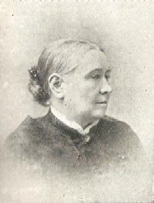
The Admiral died in 1870, and his widow Sarah Vinton Dahlgren bought a former tavern on South Mountain for use as a summer home. The tavern was founded in about 1732. Over the years, it served thousands of pioneers moving west and also functioned as a stagecoach stop throughout the 1800s, leading up to the Civil War. Confederate General D.H. Hill used it as his headquarters during the Battle of South Mountain that presaged the Battle of Antietam, 3 days later. After Mrs. Dahlgren’s death, her home again became a tavern. It continues on currently as The Old South Mountain Inn.
Mrs. Dahlgren commissioned the building of a stone chapel across the National Road, known formally as the Chapel of St. Joseph of the Sacred Heart of Jesus and much more commonly as the Dahlgren Chapel. It’s quite a sight—and it’s available for weddings through the Central Maryland Heritage League, just in case you’re interested…

From the chapel, it was an easy 45-mile trip back to my home in Catonsville. It was a great drive along some of Maryland’s best curving roads and yet another chance to see history in my own back yard.
Rick F.