I set off on Saturday, July 18th, and quickly found my way to Route 50, just outside of Winchester, Virginia. For those of you who have never had the pleasure of riding or driving on Route 50, well, time's a-wasting. It curves up and down hill and through lots of interesting old towns, offering an almost-unlimited number of fun things to do or see along the way.
My first stop was in Capon Bridge, to visit some car racing buddies and to enlist their aid in finding a rumored mansion on the banks of the Cacapon River known as the old Heffelbower estate. I found my friends' house without difficulty, since it sits surrounded by approximately 30 or more "project cars," most of them Volvo's. Despite the early hour, the whole family was up, and they gave me the grand tour of the house and grounds. Here are 18-year-old Alex "Zandur" Polimeni, father Ron, and older son Nick, standing in front of one of their SCCA racing Volvo sedans. Barely visible in the background is the top of Ron's reborn Volvo PV-544 race car, which he ran at Sebring in the 1958 12-hour race, along with many other races at Marlboro Speedway, Cumberland, and other venues back in the late 1950s and early 1960s. Nick recently brought the old racer back to life (the Volvo, not Ron!) after it sat in a field for 30 years, and the family has taken it to vintage races at Summit Point and Pittsburgh, plus the Hershey, PA vintage sports car meet.

Hiding in Nick's shop was this Ferrari 330 GT 2+2, which is receiving a considerable amount of body work and new paint, courtesy of Nick.

Now, as it happened, the entire Polimeni family had no idea where or what the old Heffelbower estate was--until Zandur wondered if it was the mansion north of town and next to an acquaintance's house. He and I promptly set off in the Z4 to see if it was the right place. After several miles of dirt roads, we found ... the old Hefflebower estate! And it was quite a sight. It appears to be undergoing an interior restoration.


As a reward for finding the estate for me, Zandur got to drive the Z4 back to his house. I suspect his grin stayed in place for hours afterward (if not days).
Continuing along Route 50, the Z4 proved its cornering, accelerating, and braking prowess as it climbed and descended the several mountain passes on the way toward Rowlesburg. I temporarily bypassed the turn to R'burg, just to revisit Cool Springs Park. I'd encountered it once before, without realizing it was a park and not just some mad collector's front yard. With an incredible assortment of steam- and gas-powered tractors, a waterwheel, several railroad cabooses, and numerous other Implements of Destruction, it continues to be quite a sight. And you can buy any number of tacky souvenirs inside the shop--and even lunch (if you dare). This tractor had the scariest-looking steering mechanism I'd ever seen on any vehicle, operated by a worm gear attached to chains and a swiveling, solid front axle.

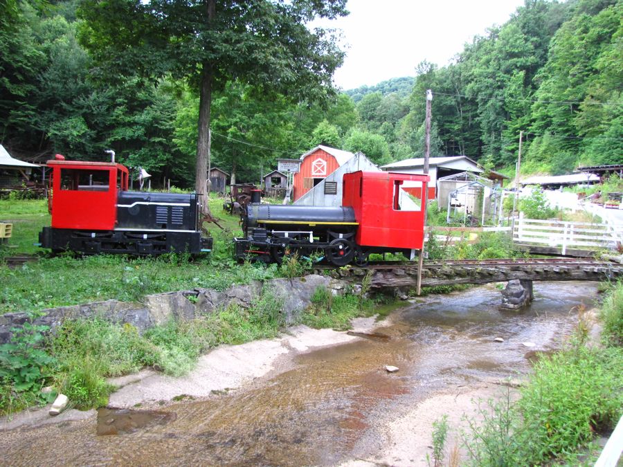
Elsewhere, several little locomotives had received fresh paint:
I also spotted (yet another) Model A Ford flatbed truck that needed all that paint and more. (Why do these trucks keep turning up on my trips? This is about the sixth one, with nary an abandoned Model A roadster, coupe, or sedan ever spotted.)

After purchasing a tank of Cool Springs Park gasoline, I backtracked to Route 72 and quickly found myself in scenic, historic Rowlesburg--just as the website and numerous roadway signs promised. My plan was to have lunch there, ask how to get to the top of Cannon Hill (to get fantastic pictures for you all), and then follow the directions. Rowlesburg, however, doesn't have any restaurants--rather a significant deficiency for a major tourist attraction. In searching for one, I at least found this split-level, split-side, and split-roof home, complete with satellite dish...
...pretty flowers (quick, Flash, what are they??)...

...and the Cheat River Tavern, which wasn't open and probably wouldn't have served lunch even if it was.

Although mid-week testing of Herr Zumo suggested that he was now working again, following a hard reset and the latest Garmin software, he was intermittently dropping satellite connections again. I negotiated around Rowlesburg the old-fashioned way, using the S.O.P. method, and somehow ended up on this railroad bridge across the Cheat River. Scenic, but no sign of Cannon Hill.

I did find a howitzer cannon of the type used on top of the hill by Union forces to (successfully) prevent the Confederates from blowing up the railroad line through town. The short barrel of the howitzer is designed to shoot high and behind fortifications. Plus, it was small enough to be disassembled and carried to distant mountain tops by mules. (The careful reader will notice a bit of foreshadowing here...)

After crossing the river, I located a cheery "Cannon Hill Park" sign, complete with a narrow but paved road leading up the mountain. This was clearly going to be a piece of cake to drive the Z4 to the top and get gorgeous pictures much like this, but better of course:

Soon, however, the road turned to dirt and gravel, with large, rain-filled potholes. Next, it began going straight uphill and around switchback bends, with a sharp mountainside to the left and an abrupt cliff on the right. Then the road surface turned to large pieces of loose rock and became progressively narrower, with about a foot on either side of the BMW. Say, where was my faithful R1200GS when I needed it?? Still, I soldiered on in first gear with the rear tires scrabbling for traction while I frantically sawed at the steering wheel to edge between the larger rocks on the path. After getting much farther than I had any right to expect, I decided to stop for a bit and reconnoiter on foot. Here's a ground-level view of the path and the Z4. (Although the picture doesn't show it, I was parked on an incline of at least 10%--it was dang steep!)

Since there hadn't been any other traffic going up or down (thank goodness, given the narrow road), I didn't feel too bad about just leaving the car sitting there. I hiked another quarter mile or so uphill, thinking that I must be near the overlook, but I quickly realized that there was still a long way to go. (After I was back home, a review of Google Maps' terrain of the area suggested that I wasn't even halfway to the top! See the squiggly little road running along the top of the mountain toward Cannon Hill.) So, with much despair and disgrace, I admitted defeat, walked back to the Z4, and then backed down the mountain path... The things I do to get pictures for you all!

Back on terra firma, I salved my wounded pride by finding a nice bridge overlooking a railroad yard. Not exactly a picture from Cannon Hill of the mighty Cheat River, with Rowlesburg nestled in its curves, but it would have to do for this trip.

At a grocery store back in town, I bought some chips and cookies for lunch and learned that the proper way to get to the top of Cannon Hill is by taking the "Jiffy Van," an AWD truck that occasionally runs tourists up there for a small fee. The road is actually closed to regular traffic (although no one told me!) Next time...
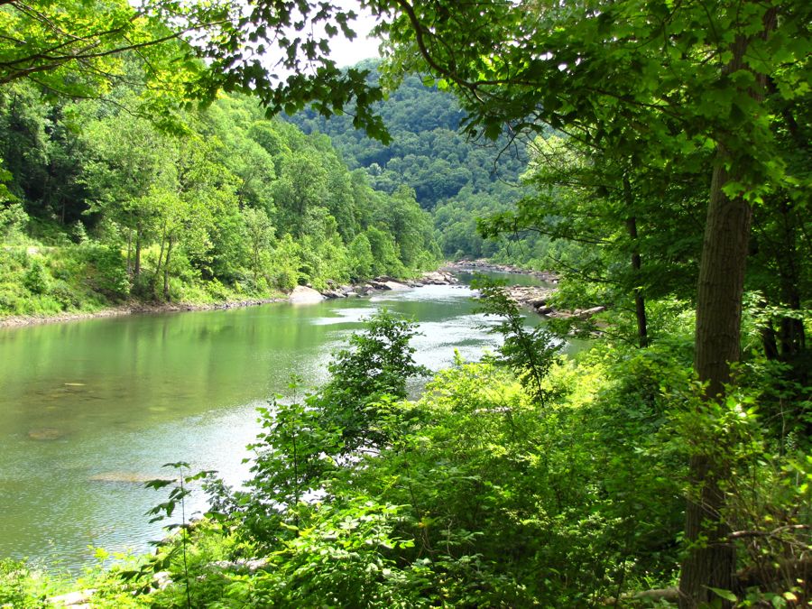
Leaving R'burg behind, I had the opportunity to drive right alongside the Cheat, with a number of turnoffs available for access to the river, whether for kayaking, photographing, or just admiring the view generally. Many of you have probably crossed the bridge across Cheat Lake, on the outskirts of Morgantown, WV. Have you ever noticed how green the water is? Well, the river is the same way.
Not far out of town, a 1907 stone viaduct carries the railroad tracks over Tray Run. There are actually three viaducts up there, the older two in ruins, but I could only catch a distant glimpse from the roadside. Nice leafy trees block most of the view, even though the viaduct is 445' long and 150' high. I'm sure it's impressive in the winter...

Further on, I stopped to get a picture of an old footbridge crossing the river, but couldn't find a decent vantage spot. However, someone had thoughtfully left a couple of spare tires for me, in case I'd picked up a flat or two in my mountain-climbing adventure. (And yes--these tires really were as big as shown in the picture. They absolutely dwarfed the wee Z4.)

Approaching Caddell, I thought I saw some factory-type ruins lurking through the trees. A bit of exploring turned up this pretty lily pond together with said ruins. I don't know what it used to be, but it's currently used for government "height training," whatever that might be. Perhaps best not to know! Fortunately, no government folks were around to run me off the property--or to train me in the proper use of heights.

While Rowlesburg had been just a bit of a disappointment, given my website-fed expectations, the town of Terra Alta was an unparalleled delight. Perched on a steep hillside, it was one of the most "vertical" places I've seen. This view of Chestnut Street illustrates the steep grades that lead from level to level in the town:

The train tracks go through the lowest part of Terra Alta, following Salt Lick Creek--and offering a behind-the-scenes look at the bordering houses and businesses. Many of which were vacant and in disrepair, sadly.

As fun as it was to explore Terra Alta, the afternoon was getting quite late and I still had many miles to go. Naturally, just a few miles outside of town, I had to pull over for another photo op. This part of West Virginia seemed to offer an unlimited supply of vistas, mountains, streams, and quaint towns. I should have made it a two-day (if not two-week) trip.

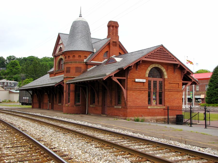
My next scheduled stop was Oakland, MD, a short way over the line from West Virginia, to find its historic train station. It was well worth the effort.
Nearby was the site of the once-popular J.J. Reynolds' Café and Saloon. It burned in 1898, taking most of the block with it. It was replaced with another restaurant, including this ornate fireplace--which was all that survived the fire of 1994. This may not be the best spot for another restaurant attempt...

Near the station, the Oakland Historical Society featured the facade from the otherwise long-gone Deer Park Hotel. Immediately next door was this burial-vault-like mound. I looked for any identifying information but found none. Subsequent Internet research identified it as the "Gas House," which was used to house the gas canisters that provided light for the hotel and grounds. The stone and dirt mound was a safety precaution, to help limit damage should an explosion occur!

Across the street was the "Church of Presidents," so-named because four U.S. Presidents had attended services there at one time or another.

All this sightseeing had made me really late, and I still wanted to find the long-lost town of Barnum, WV and the George W. Washington estate and mansion. Hustling along Route 135 toward Bloomington, Luke, and Westernport, MD, I soon reached the turnoff that would theoretically lead me to Barnum, on the banks of my old friend, the North Branch of the Potomac River. Here is the Savage River, divided into thirds by two islands, shortly before it joins the Potomac.

On a previous motorcycle trip (see Ghost Towns of the Upper Potomac), I'd tried to find Barnum and ended up misidentifying its location. Needless to say, I had to go back and find the real town itself. Based on considerable research into its location, I did, indeed, find Barnum. Or where it had been, anyway. Next to nothing remained except for this support for the long-gone "interstate bridge," so-named because it ran between Maryland to the northwest and West Virginia to the southeast. I also found the Bait House, but it was a later addition to the town. The original coal town and all its dwellings were lost to time and floods.

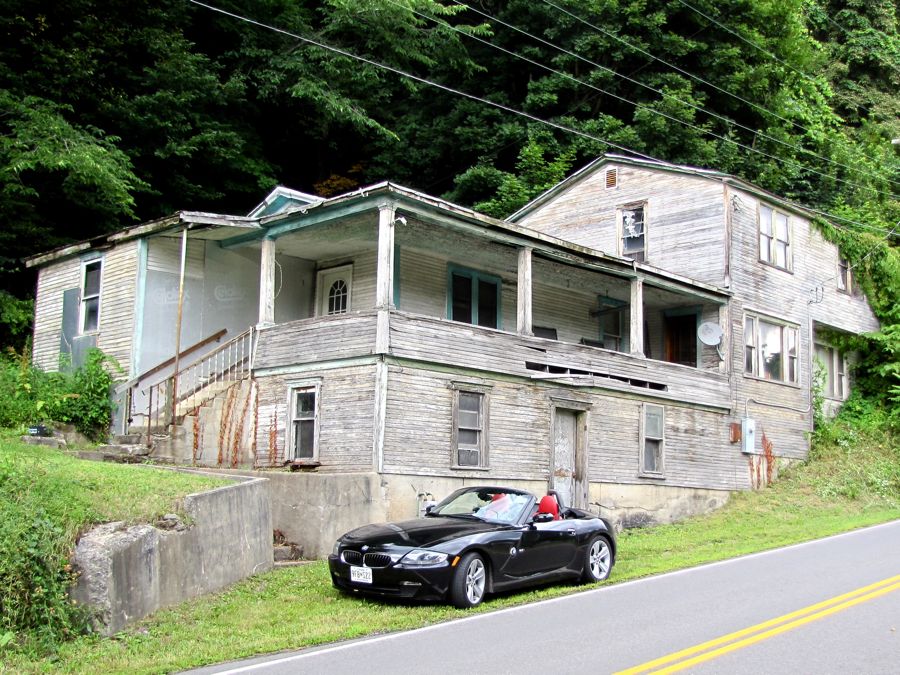
Backtracking to Route 135, I continued to press on toward home--stopping, of course, for a picture of this abandoned house in Short Gap, WV that epitomized the numerous such dwellings I saw throughout the trip.

Short Gap also featured Stewart's Tavern and Inn, which originally started business in about 1730 on the other side of the road--leading, naturally, to the question "Why did the tavern cross the road?"

My arrival in Springfield, WV signaled the start of the search for George W. Washington's home, named Ridgedale and also the Washington Bottom Farm. A descendant of a brother of the first President, George W. (uh, that's Washington, remember!) built his farm house in about 1835 on land that had originally been surveyed by the original George Washington in the mid-1700s. No address for the farm was available from my Internet research, but some careful Google Map satellite viewing provided a possible location. Following a dirt road off of Route 28, I negotiated this "water crossing" (all of 6" deep)...

...and found the mansion itself, looking resplendent in the late-afternoon sun. The house was undergoing restoration, which is described in some detail at National Register article. What I wouldn't have given to get a tour of the inside! A number of other structures were present, some old, some newer, and it looked like it remains a working farm.

The Zumo GPS, which managed to come back to life just when the route got the most complicated, thankfully, was now predicting an arrival time back home of about 10:30 PM, so I decided to press on with no further stops no matter what. Riiight... Before long I happened across the South Branch of the Potomac River, which clearly cried out to be photographed...

...and 20 minutes late I couldn't resist this view of the South Branch. (Just for you, Tina!)

As the sun was starting to set, I was still climbing mountain passes and taking hairpin after hairpin in the willing Z4. But I couldn't drive by this old place...

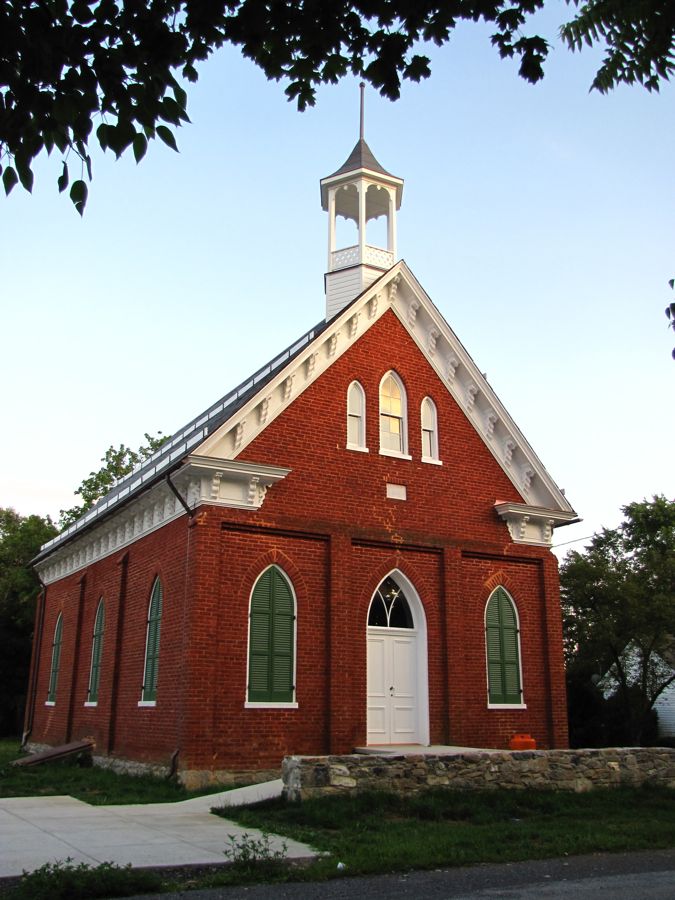
...or this 1882 church in Gerrardstown...
...or the 1743 log home that later became known as the Gerard House, named after the founder of Gerrardstown.

Despite these irresistable stops, plus one for dinner, I still managed to return to Catonsville no later than 11:00 pm, after 485 miles and 15 1/2 hours of driving and exploring. Definitely should've made it a two-day trip! I enjoyed every minute (well, maybe not the part about backing down the mountain...) and every sight along the way. If anyone would like the Mapsource route for this tour, don't hesitate to ask.
Rick F.