Friday
As usual, getting there was half the fun. I took 70, 340, Summit Point Road, Old Charles Town Road, Martinsburg Pike, and 37 to reach the fabled Route 50, starting just west of Winchester, VA. Along the way, there were low bridges, such as this one over Opequon Creek...

...and not so low ones, including this bridge over the Cacapon River in (naturally) Capon Bridge, WV.

The view from the bridge across the Cacapon was pretty enough, but I was disappointed to find that the old church had been converted to someone's Big Garage. This appears to be a fairly common fate for dilapidated churches. For Arlo Guthrie fans, there was no sign of Ray or Alice in this church (but another Alice showed up later in the trip).


Further along Route 50, I went looking for the not-very-famous Hanging Rock. I found the unincorporated town of Hanging Rock, but no sign of the rock formation itself. Rural West Virginia is home to many thousands of trailer homes. In the process of failing to locate Hanging Rock, I at least ran across this particular example of a trailer home. It wasn't the most run-down one we were to encounter on the trip, but it definitely rated an Honorable Mention.

Near Romney, WV, sits the Indian Mound Cemetery. A highway marker helpfully indicated that nearby there was an original, unmolested Indian burial mound dating from about 500 to 1000 AD and measuring 7' high and 15' in diameter. The sign didn't indicate where the original mound was located, however--and, naturally, I couldn't find it. So far, I was batting close to zero in terms of finding scenic or historic sites that I'd noticed along the route. I later learned that the current Indian Mound Cemetery is actually built right around the original Indian mound. In other words, it was in plain sight while I toured the cemetery!


I stopped for lunch in Gormania, WV, which sits immediately across the North Branch of the Potomac River from its (largely disappeared) sister town of Gorman, MD. This town doesn't seem to change much over time--and likely couldn't tolerate much change of any sort anyway.

I decided to make a short detour from my planned route so that I could revisit Bayard, WV. As chronicled in Ghost Towns of the Upper Potomac, this was one of many coal mining towns along the river, and one of the relatively few that still has a number of the original buildings in place despite the occasional floods.

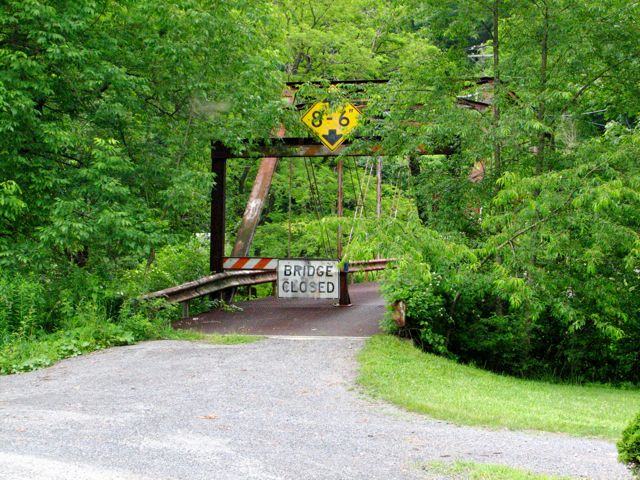
Now, I was planning on crossing the Potomac at Bayard, since the Evil Twins Garmin and Google clearly indicated a bridge there. The bridge, however, turned out to be closed to vehicular traffic. Well, to non-GS vehicular traffic anyway, as I chose to scoff at mere signs and cross there anyway, rather than backtracking the several miles to Gormania and crossing properly. (Motorcycles rock!)
Perhaps in punishment for my wanton act of bridge crossing, it began to rain shortly after I returned to Route 50. I took sanctuary on the covered front porch of a church (that looked to have been a hunting lodge in a previous life). I put on my rain gear, and set back off on the trip.
Riding in the rain is seldom much fun of course--but consider the fellow cyclist I saw heading in the opposite direction: He was bicycling in the rain, up a very steep mountain, and his mount was a classic "penny farthing" bike--the kind with the huge front wheel and tiny rear wheel. He must have been 6 feet off the ground! (Also, penny farthings don't have changeable gears; you're stuck with the ratio of pedal diameter to front wheel diameter.) Now that was an intrepid cyclist! I promptly vowed to cease griping about the rain. (Picture courtesy of Wikipedia.)

Once I reached the mighty Cheat River, I decided to follow a little dirt road along its banks for a ways. Most rivers end up carving canyons or valleys over the course of thousands of years, and this one was no exception. Its handiwork was evident:

While I was there, I figured I better get a motorcycle-with-river picture for Tina:

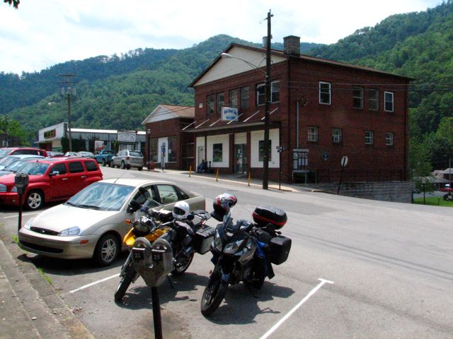
Before I knew it, I'd arrived in Philippi (pronounced Phil'-ih-pee, by the way and named after Philip Barbour, an early member of Congress and the Supreme Court). I checked in at the Philippi Lodging motel--the only motel in Philippi, but a very clean and friendly one. Buzz arrived at 2:55, just in time for us to unload his gear into the motel before a Monumental Thunderstorm commenced its action precisely at 3:00. We were surprised, since neither weather.com nor noaa.gov had mentioned any possibility of thunderstorms for Friday, but we soon learned that it rains every day in West Virginia starting precisely at 3:00 in the afternoon.
After the storm had passed through, we motored into downtown Philippi for dinner at the Medallion Restaurant. They offered a very good buffet dinner for $6.50, with service by a Rather Cute Waitress. Well, I didn't get her picture, but the stately Philippi Courthouse was nearby and practically begged to be photographed.

Saturday
We got underway the next morning at 8:00, with overcast skies but a weather report that indicated only a minor chance of isolated thunderstorms late in the day. Our route was a slightly modified version of the "Central West Virginia Loop" from Great Roads, Great Rides by Jennings Glen and Dan Bard. It sounded--and quickly proved to be--quite attractive, with mile after mile of twisting, little-traveled roads and no shortage of pretty sights.
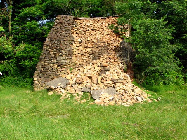
We found what was left of the iron furnace in Valley Furnace, WV, without difficulty. The furnace used to be about twice this tall: apparently the residents of the little town have borrowed freely of the stones over the years for one project or another. Before long, passers-by may wonder how the town ever got its name!
As we've come to expect in West Virginia, almost any place you happened to look was scenic:

Following Jonathan Run Road on top of Pifer Mountain, we happened across a great view of row after row of mountain tops, with mist and fog filling the valleys in between.


Many of the roads we took were narrow (but paved) lanes that meandered through forests and alongside streams, as illustrated here by Buzz and his V-Strom and me and my R1200GS. This particular road was so pretty that I returned to it on my way home on Monday--and ended up dodging no fewer than 6 deer in the space of about 5 miles! One doe and fawn ran away from me, right down the road itself. Mom keep trying to jump into the woods, but Baby was ahead and kept to the road. Mom wouldn't desert the little one and dutifully returned each time to the road to stay between the Evil Aggressor (uh, that was me) and Baby. Fortunately, there were no close calls for me or the wildlife.


Before long, we reached the Cheat River again and crossed over into St. George (formerly Fort Minear). When a new bridge is built over a river, the builders generally leave the abutments for the old bridge in place. Now I know why--it's to provide a place for new forests to spring up...

Meandering along Limestone Road and other little venues outside of St. George, we were surprised to find several small mountain-top churches in areas that couldn't have had more than 5 houses within a 10-mile radius. Most of them appeared to be still in regular use. There were also quite a number of pretty vistas, reminding us of how "vertical" West Virginia is in most places.

Incidentally, for anyone planning to following this same route, the Evil Twins (G & G) insist on showing Limestone Road as "Holly Meadows Road." Nonetheless, it was exactly where the authors said it would be--the very first left turn after crossing the bridge into St. George.
Many of you have probably seen the giant "windmill farm" located along a mountain ridge on Route 219, near Pierce, WV. I decided to ride up a private gravel road to get a better picture of these energy producers, but there wasn't much of a vantage point. Meanwhile, Buzz waited at the base of the road and got a dramatic picture of me and one of these imposing devices. Although the rotors of the windmills appear to turn very slowly, I'm told that their speed at the tips is over 100 mph.

Our route later took us very near the Fairfax Stone, so we stopped there briefly so Buzz could admire the official headwaters of the Potomac River. On this day, the spring provided about 10 drops of water per minute.

As long as we were slightly off the scheduled route, we went a little further and swung by the almost-abandoned town of Kempton, MD. We met a pleasant older woman who told us quite a bit about what the town had been like and where things had been located.

Before long, we reached the town of Davis and the nearby Blackwater Falls State Park. After an excellent lunch at the lodge, we did a little hiking and sightseeing, including this overlook of the Blackwater River...

...and the Blackwater Falls themselves. The water was slightly amber-colored due to a substantial amount of tannin from pine trees and other sources.

Leaving the state park, we passed alongside Mt. Storm Lake, a mammoth, 1,200-acre lake that is as deep as 200 feet in places. Having read about this area, we stopped briefly to feel the temperature of the water, which, at about 3,200 feet elevation, one might expect to be fairly cold.

One would be wrong, however, since this lake serves the purpose of cooling the adjacent Mt. Storm coal-fired power plant. The water temperature never goes below about 50 degrees, even in the dead of winter, and it was a good 85 or more when we were there! The entire lake is cycled through the cooling system every 2 1/2 days...

Leaving the lakeside, Buzz demonstrates the V-Strom's off-pavement capability and I demonstrate my ability to accost complete strangers (and their babies) looking for information to report to all of you:


Continuing on, we soon encountered Route 93, which took us down off of the mountain to Scherr in one of the best series of tight corners we had seen anywhere. No pictures, however, as we were too intent on enjoying the winding road.
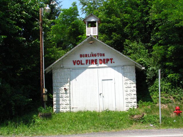
The little town of Burlington, WV boasted this impressive firefighting facility...
...while Old Fields had the stately Willow-Wall plantation, built around 1805.

As we motored south, once again--this time on Route 220--we began to notice considerable darkening of the sky, major cloud formations, etc., but no obvious sign of rain. That outlook proved to be short-lived, and at precisely 3:00 PM, we had to stop to put on our rain gear. For me, that meant struggling to get generic rain pants on over my size-13 boots and the rain jacket under my riding jacket, since it's too small to fit over the outside. All this takes me several minutes and leaves me exhausted! Buzz, smugly wearing his Aerostich Roadcrafter suit, merely had to tuck his pants legs back inside the 'Stich. But then he remembered that his fabric saddlebags needed to have their rain covers put on, which were hiding someplace difficult to reach, so he got to have his share of fun, too.
As we reached Moorefield, we holed up in a McDonalds to get a snack and wait out what had developed into a major thunderstorm. We sat there for an hour, chatting with local residents, monitoring a tiny weather map I could call up on my Blackberry, and deciding to abandon the rest of our planned route for the day and take the most direct path to Seneca Rocks and our motel for the night--Yokum's Vacationland.
With the roads nicely scrubbed by the thunderstorm, we set off in a light rain toward our destination. Somehow, the road alternated between being soaked for a mile and then being nearly dry for a mile, and back and forth. The sun would come out, then it would rain some more, etc. Very odd, even by West Virginia standards!
Soon, we caught up to 3 Harley Davidsons that were proceeding at an incredibly slow pace toward Seneca Rocks. For corners marked 40 mph, which could be taken in the dry between 50 and 60 mph, and which we were taking at about 40 in the wet, they slowed down to less than 25 mph. At one point, Buzz claimed that a butterfly caught up to him and easily passed him while he was going so slowly behind the Hardlys. At the first opportunity, I accelerated moderately to pass them, but the back two promptly accelerated with all their might, and I ran out of passing zone before I could get by. Nice guys! The next passing zone saw a very brief comparison of BMW and Suzuki horsepower compared to H-D, and we were by and away.
Now, the problem with passing Really Slow Vehicles is that, as soon as you get by, you discover a must-have photo opportunity. But you don't stop, because then the RSV's will get by and you'll have to pass them all over again. So, I didn't stop for what would have been a beautiful picture of Champe Rocks, with the late afternoon sun (momentarily!) shining on the top of the ridge, with a shadowy and wet mountain base, and a bit of mist tendriling about... You'll have to make do with this photo that I borrowed from the Mountain River Retreat web site.

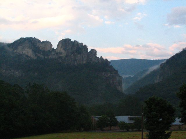
Before long, we reached Yokum's Vacationland, met 88-year-old owner Shirley Yokum, and got checked into our room above the store. Within minutes, more thunderstorms showed up off and on for the rest of the night. In between storms, I managed a brief picture of the Seneca Rocks...
...and a picture of Buzz in our room, working on his laptop.

After a good pizza at Yokum's restaurant, I tried to get a picture of the massive lightning strikes going on around us. The only one that worked is here, with the bolt visible in the upper right hand corner and serving to light up the cliffs a bit. We slept well that night, since there's nothing like being safe, sound, and dry in the midst of clamoring storms.

Sunday
The next morning dawned overcast, foggy, and generally uninviting. But there wasn't any rain actively falling, the roads were merely wet, and the sun itself was trying to break through all the clouds.

This is what a Yokum's Vacationland store and motel look like...

...and this is what Buzz looks like as he puts on the rain covers, just in case.

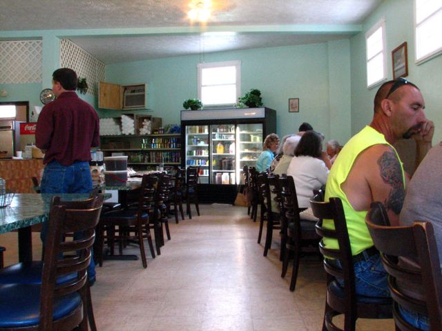
Since the other Yokum's Restaurant, which offered breakfast, was 1/2 mile in the wrong direction, we rode 30 miles in the right direction before finding a restaurant that was open on a Sunday morning. This one proved to be quite charming.

We were well taken care of by the owner, Alice. We never did see a sign or name for the restaurant, so it's only fitting that we refer to it as "Alice's Restaurant."

Reluctantly, we skipped our planned side trip to the top of Spruce Knob, which, at 4860 feet, is the highest point in West Virginia. Many hours of hard rain were likely to have turned the dirt "State route 112" into a steeply uphill river of mud, or at least that's what we figured. We'll get there the next time!
In Green Bank, we found this International Order of Odd Fellows hall, which appeared not to have seen any Odd (or other) Fellows for quite some time.


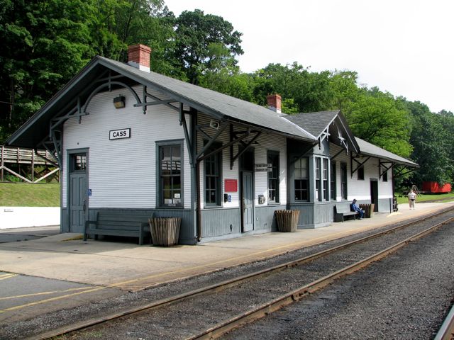
Having been by the Green Bank Observatory previously (see West Virginia (GPS, Gravel, And All!)), we didn't stop this time, but we did make a point of checking out the town of Cass more thoroughly, including the train station...
...the company store...

...and of course the imposing Shay steam locomotive that used to carry supplies and lumberjacks up the mountain and tons of lumber back down.
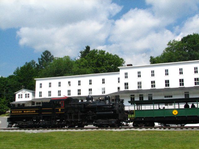
Cass is now a state park and is one of the only largely complete former coal or lumber towns still standing in West Virginia, complete with company-built houses for the workers, the Luke "mansion," former jail, churches, etc. A great place for a visit, and an even better one for a train ride--when you have enough time, which we didn't. Our goal was to return back to Philippi before 3:00, when we figured the inevitable thunderstorms would set in.
Our Great Roads, Great Rides route continued to feature terrific roads and scenery. Route 15 twisted and turned for all it was worth and led us to Webster Springs, a former resort town with hot sulfur springs (that you could drink from via a handy fountain--tasted quite salty). We stopped for lunch at the Main Street Cafe, where we found great food, many dressed-up folks getting lunch after church, and Various Others.
We walked around the town a bit and chatted with some of the residents. It was a familiar refrain: "When the coal mines closed, and the trees were all logged, there wasn't any work. All the young folks have left." Some of these towns have a chance through tourism--and maybe, given the energy situation, coal will make a comeback--but for now, they are just slowly dying out, and it's sad.


Now we all know that West Virginia is reputed to have many derelict cars up on blocks in people's front yards. But derelict 40' cabin cruisers??

At the cleverly named "Government Access Road," we stopped to look at the Holly River.

At Falls Mill, we decided on the spur of the moment to investigate whether there was (i) a mill (not any more) or (ii) a waterfall (yes, still there). In the parking lot, we encountered a couple of guys from New Jersey and western Pennsylvania, riding an R1150GS and a K100, respectively. The GS, with over 120,000 miles on it, looked like GS's are supposed to look:

The falls themselves were beautiful, cool, and inviting--although one of the people there warned us to watch out for snakes. We didn't see any, and the spot was quite enjoyable.

Further upstream, a young couple enjoyed some fishing:

As we motored on, at exactly 3:00 PM it began to rain... This time, fortunately, it was only a few drops and it quickly ended--hurrah. Still, we wanted to get back to Philippi, since the day was becoming extremely overcast. In our haste, we passed a very slow blue sedan--causing me to miss a picture of a school bus that had partially cracked in half! (Just how big were those students, anyway??) Not long after, we passed a farmer towing a trailer--and promptly missed a picture of a glorious abandoned house in a valley. I swear, I'm never passing anybody again. I'll just find something to take a picture of, instead.
Speaking of which, here's another West Virginia meadow and abandoned barn in the gloom, not far from Philippi.

Shortly after checking back into the Philippi Lodging motel, yet another major thunderstorm arrived, drenching everything in sight. I guess we timed it just right. After dinner, which included the largest piece of chocolate cake I've ever eaten--I swear, I think the waitresses had a pool going on whether I could finish it--we watched "Mr. and Mrs. Smith" on the TV and did some route planning for our trips home the next day.
Monday
Before heading out, I did a little more sightseeing in Philippi. The covered bridge is one of the longest in the country, the local police station had considerable charm, and the sky behind the Presbyterian Church promised a glorious day for riding.


Near Etam, I found this ruined structure--and I have no idea what it used to be. The hexagonal central part, with furnace-like door openings, still stands, but the rest of the building has collapsed. Anyone have any ideas?

The little-known Dog Run Bridge didn't seem to mind that someone left an R1200GS on it whilst running round taking pictures...

Back on Route 50, I encountered this old stone tavern, which was built in 1825. It also featured a pretty vista to the north.


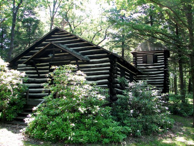
As part of my return trip, I wanted to revisit Kitzmiller, MD. I hadn't paid much attention here on my "Ghost Towns" tour last year, so I set off on a detour to see what I'd missed. Along the way, I encountered the perfect log cabin. I've always wanted one, and this one even had a nifty tower! What better way to fullfill the dreams of my 10-year-old former self? Well, it actually turned out to be a log church, not a home at all. Oh well, it still looked cool.
Arriving in Kitzmiller, I found my old friend the North Branch of the Potomac River...

...and I quickly located what used to be Coffman's Department Store back in the early 1900s. The building still stands, and it survived the devastating flood of 1924. All the buildings shown to the right in the old photograph (from Ghost Towns of the Upper Potomac are long gone, but the department store and the two buildings next to it are still there, as is the house pictured at the end of the street. (Well, sort of. The back of the building next to Coffman's was recently washed away by the creek that runs underneath it. Its days may be numbered.)


By chance, I encountered Bernadine Evans who, at age six, got her first ice cream cone in Coffman's. She now owns the building and lives in several of its rooms, collecting antiques. She loves the old place and its history, and wants to ensure that it survives (despite the town's interest in leveling the whole block). You rock, Bernadine!

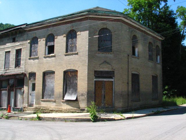
This building, at the end of Bernadine's block, used to be the bank.
Around the corner, Shirl's Restaurant used to feature Coke products, while next door, Shirl's Ceramics served Pepsi. The upper right portion of the pottery building is "gone with the wind."

Riding across the hills back to Route 50, I decided I needed a flower picture for Jody to identify. So, Flash, here's your latest challenge!

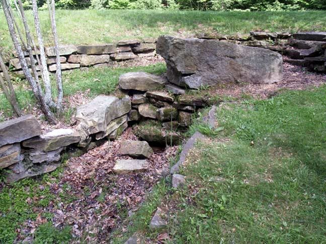
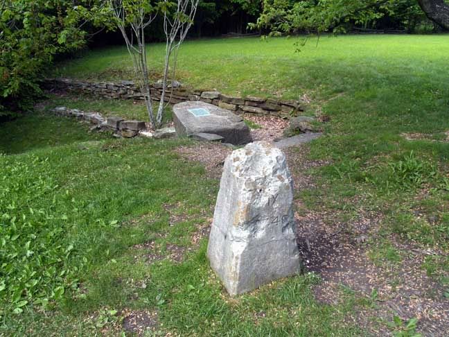
Near Claysville on Route 50, I went by a little sign that said "Nancy Hanks Monument." I'd also seen it at the start of the weekend on Friday, and I'd wondered who Nancy Hanks was. This time, I decided to find out. I followed the first road for so long, I'd just about decided that I'd missed the monument--when lo and behold, another sign indicated a turn onto a new, very narrow road. The whole process was repeated again, I was just about to turn around and give up, when yet another sign encouraged me to continue.
During the 10 or so miles that I was riding, I tried to remember who she was. Related to Tom Hanks? No, that didn't sound right. Related to Abraham Lincoln? That rang a faint bell. Eventually, I reached the monument, marking the birthplace of Nancy Hanks, in 1782, and identifying her as Lincoln's mother. A very old log cabin was there, but I believe it's a replica and not the one she was born in. Regardless, it proved to be a fun side excursion. The cabin had seen better days, but a peek through the broken windows revealed some furnishings inside.


As the thunderclouds began to form, I picked up my pace to arrive home before it rained. The number of pictures I took from then on suffered a bit, naturally. However, if you've stuck with me this far, I'll leave you with one more rural West Virginia scene: an ancient International pickup truck, that appears destined to become a planter.

All in all, it was yet another fabulous joint adventure with Buzz, and West Virginia once again put its beauty and history on display for us. It's time to start planning the next trip there!
Rick F.